Welcome to Ha Giang Loop with Phieu Ha Giang, where we invite you to embark on an exciting adventure through the beautiful countryside of Vietnam. Our motorbike tours and Car tour or Ha Giang Loop Jeep tour offer a unique and authentic way to explore the stunning landscapes and hidden gems of this fascinating country. Whether you are an experienced rider or a beginner, our expert guides will ensure you have a safe and unforgettable experience. So join us for a thrilling ride and discover the real Vietnam!
The Ha Giang Loop is Northern Vietnam’s most iconic adventure route, taking travelers through the Dong Van Karst Plateau, legendary mountain passes, and ethnic villages that remain largely untouched by mass tourism.
With extensive tour operation experience, Phieu Travel delivers Ha Giang Loop journeys that are safe, well-organized, and culturally immersive – ideal for both first-time visitors and travelers seeking deeper, more specialized experiences.
The Ha Giang Loop is Northern Vietnam’s most iconic adventure route
About PhieuTravel
Phieu Travel is a reputable local tour operator based in Ha Giang, specializing in Ha Giang Loop adventures – the most spectacular and celebrated mountain route in Northern Vietnam.
With over 15 years of experience, we have accompanied more than 20,000 travelers from around the world, ensuring every journey is operated with the highest standards of safety, professionalism, and authenticity.
Each itinerary is carefully crafted – from route selection and transportation to rest stops, cultural encounters, and local cuisine. Every journey with Phieu Travel is designed to be complete and meaningful, allowing travelers not only to conquer dramatic landscapes but also to understand and feel the rhythm, traditions and daily life of Vietnam’s northern highlands.
Phieu Travel is more than a tour provider – we are your trusted companion, delivering authentic, safe and memorable Ha Giang Loop experiences.
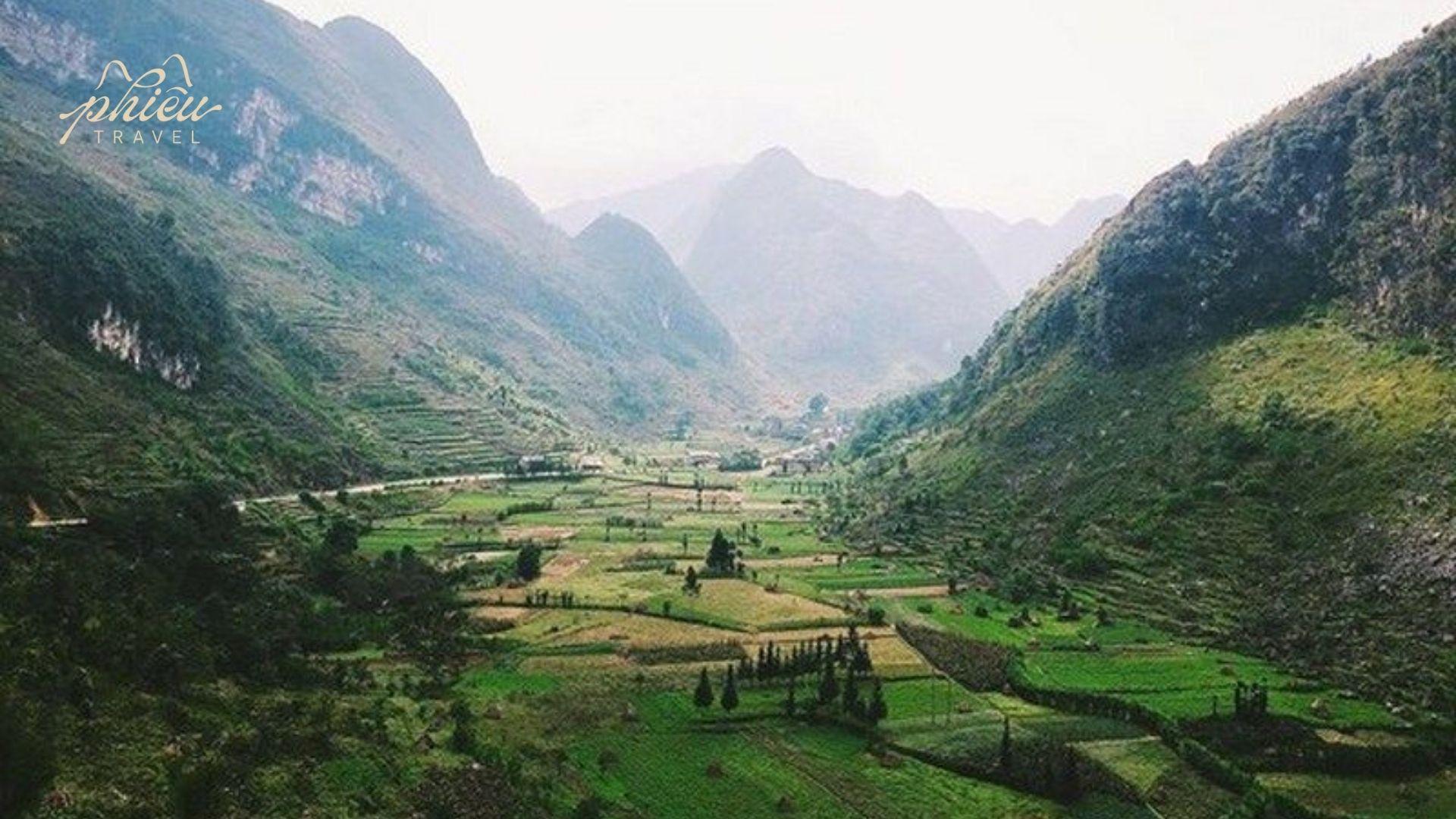
Ha Giang – Vietnam’s Northernmost Land with the Soul of Stone Mountains
Ha Giang is Vietnam’s northernmost province, where limestone terrain dominates the landscape, creating one of Southeast Asia’s most striking mountain regions. Located within the Dong Van Karst Plateau Global Geopark (UNESCO), Ha Giang is renowned not only for its rugged topography, deep gorges, and steep mountain passes, but also for its profound cultural heritage preserved through centuries of life by ethnic minority communities.
With its year-round cool climate, distinctly changing seasonal scenery, and slow-paced highland lifestyle, Ha Giang stands apart from other destinations in Vietnam. This is not a place for mass tourism, but for travelers seeking authenticity, depth, and genuine connection.
From this very context, the Ha Giang Loop emerged as the most complete way to explore Ha Giang-engaging not only the eyes, but the emotions.
Ha Giang stands apart from other destinations in Vietnam
Destinations That Shape the Soul of the Ha Giang Loop
Each segment of the Ha Giang Loop is defined by destinations of exceptional scenic or cultural value. Phieu Travel curates and organizes these highlights within our Destination system, helping travelers understand each landmark before setting foot there.
Quan Ba – Heaven’s Gate & the Twin Mountains (Fairy Bosom)
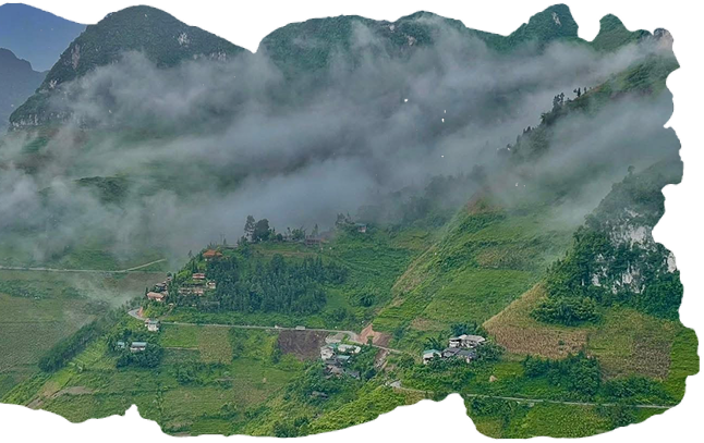
Located approximately 43 km north of Ha Giang City, Quan Ba marks the beginning of the Ha Giang Loop and serves as the gateway to the Dong Van Karst Plateau. Along National Highway 4C-known as the Happiness Road-the landscape transitions from gentle hills to towering limestone peaks and misty valleys.
The most notable stop is Quan Ba Heaven’s Gate, sitting at over 1,500 meters above sea level, offering panoramic views of terraced fields, sharp limestone ridges, and expansive valleys stretching toward the horizon.
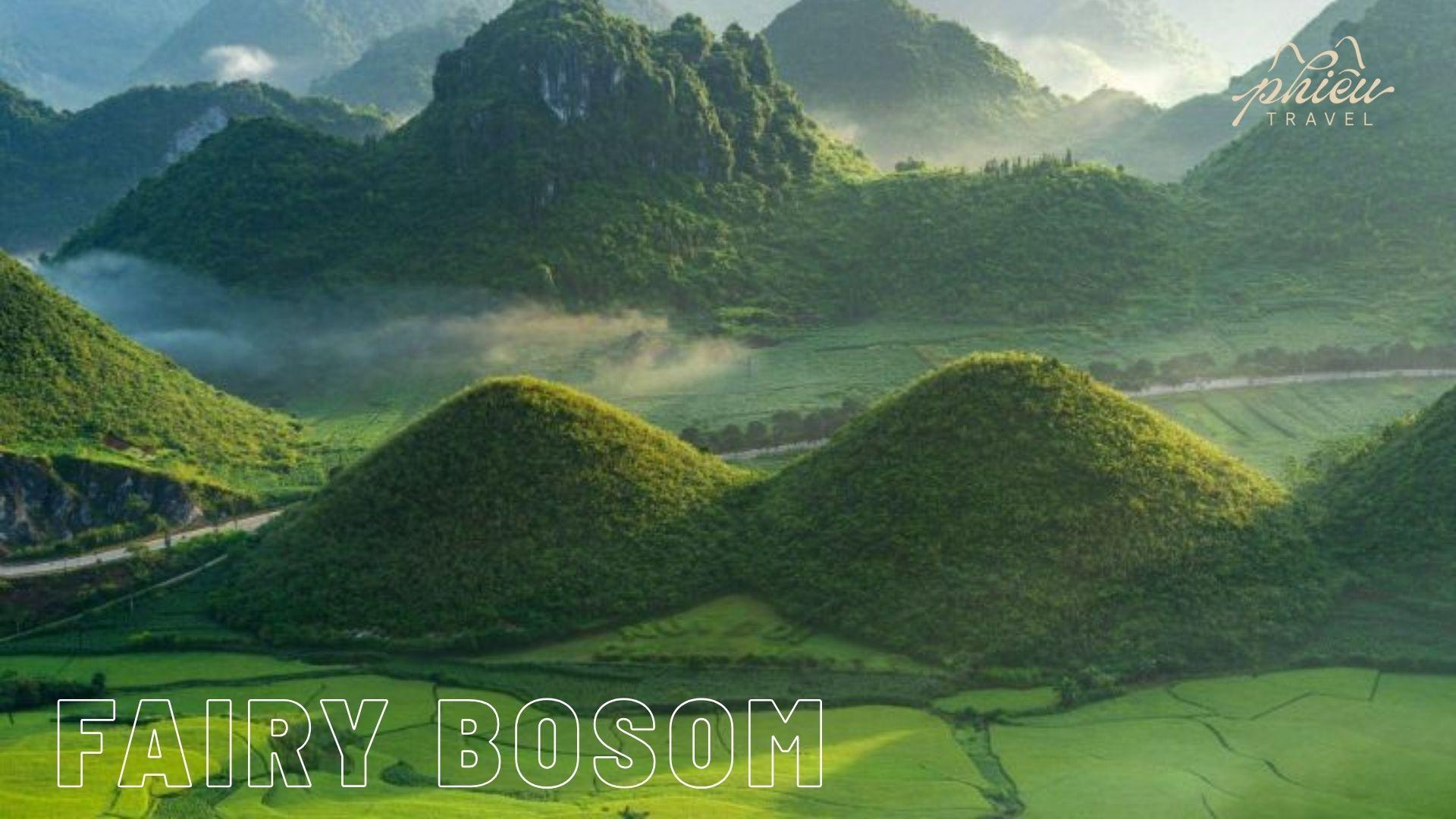
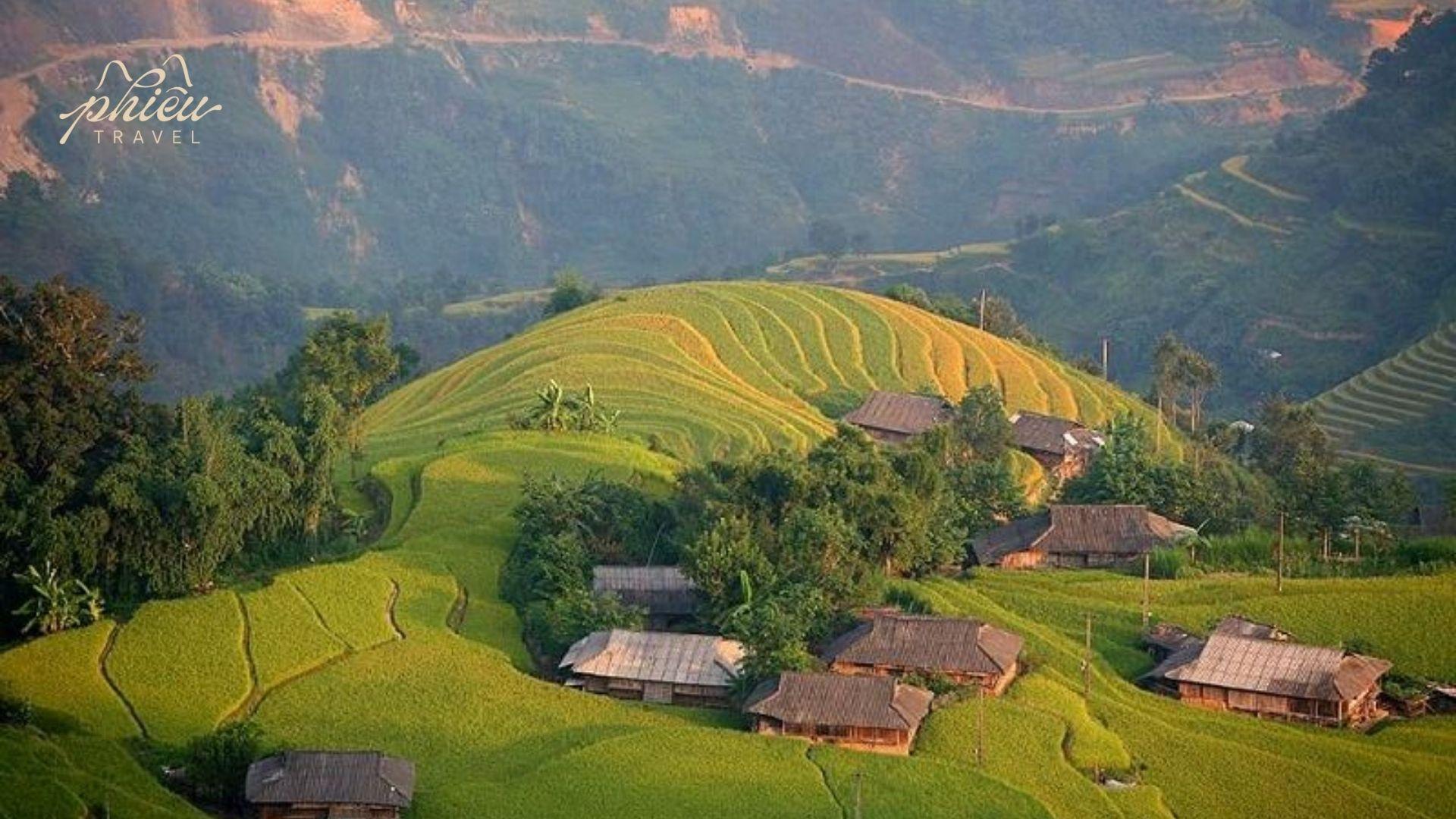
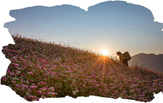
Below lies the Quan Ba Twin Mountains, also known as the “Twin Fairy Mountains,” associated with a local legend of a fairy nurturing her child. Whether in lush green summer, golden harvest season, or during October–November when buckwheat flowers bloom, this site remains one of Ha Giang’s most photographed icons-majestic yet poetic.
Below lies the Quan Ba Twin Mountains, also known as the “Twin Fairy Mountains,” associated with a local legend of a fairy nurturing her child.
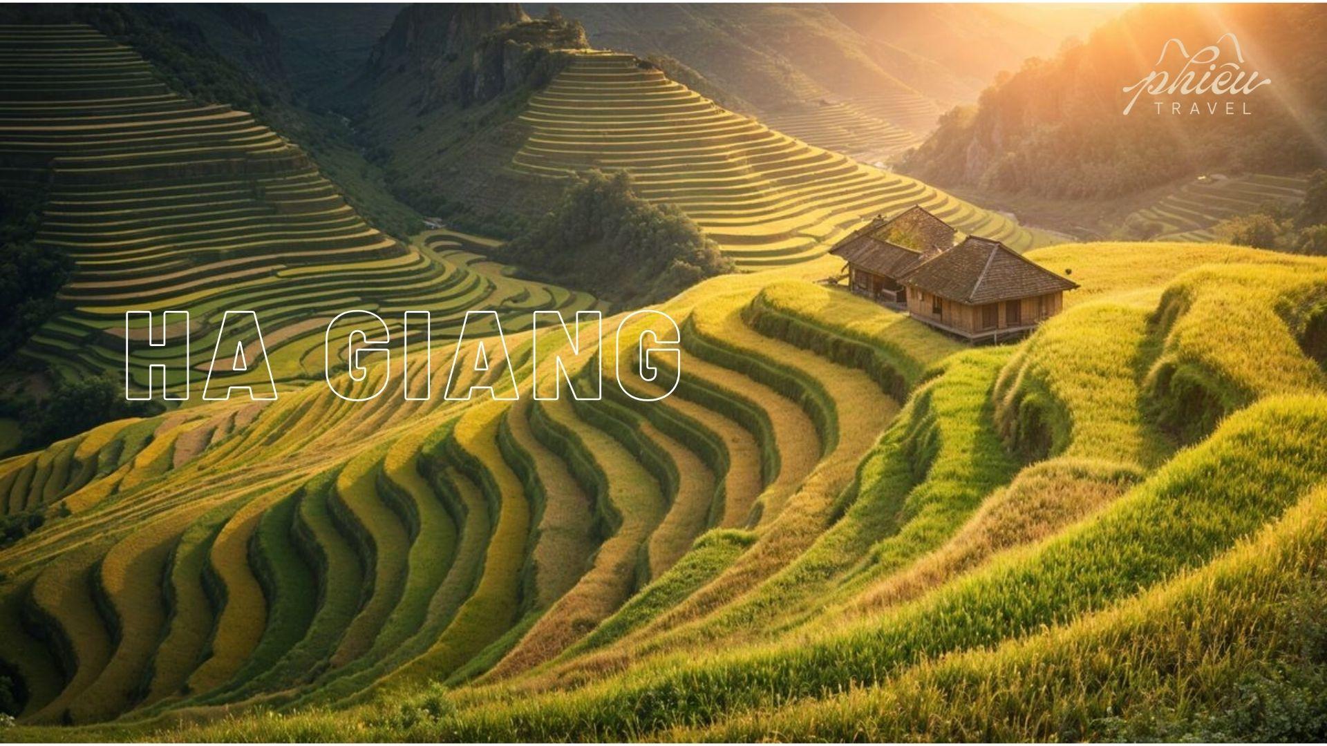
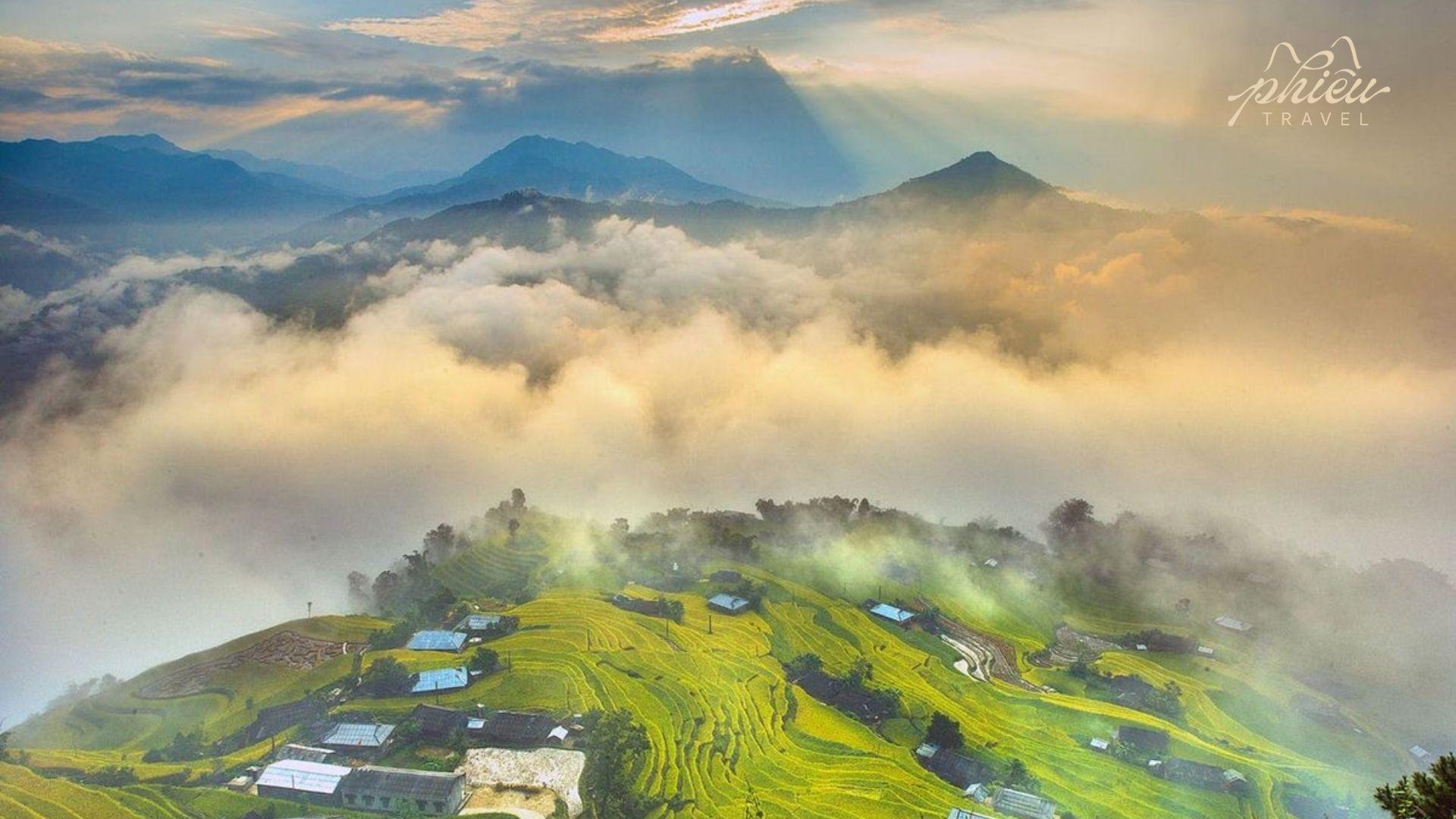
Yen Minh – Pine Forests, Terraced Fields, and Highland Fresh Air
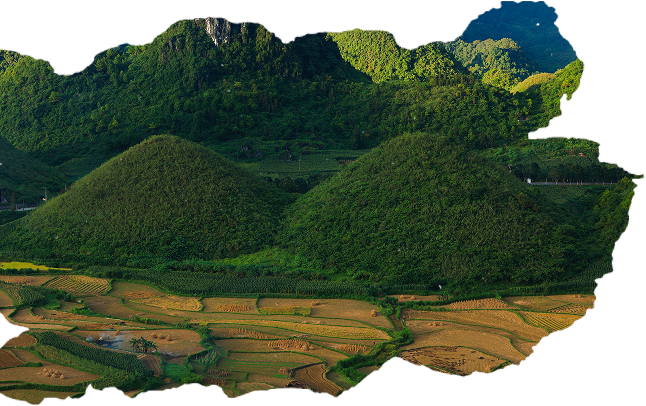
Leaving Quan Ba, the journey continues approximately 41 km to Yen Minh, where the scenery softens into peaceful, open highland landscapes. A defining highlight is the Yen Minh Pine Forest, spanning nearly 100 hectares from Na Khe Commune to Yen Minh Town, featuring straight rows of pine trees, cool air, and early morning mist drifting across the hills-one of Northern Vietnam’s most beautiful pine forests.
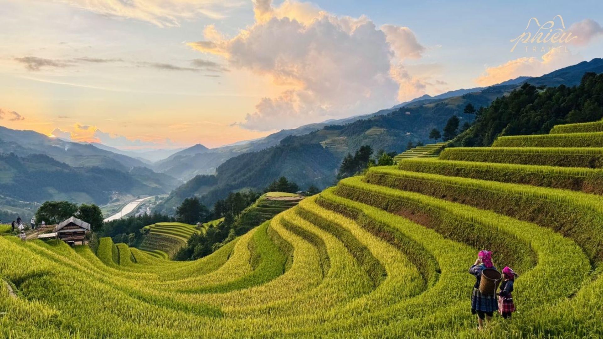
Beyond the forest lie terraced rice fields carved into the mountainsides, turning vibrant green in spring and summer and golden in autumn, shaped by generations of H’Mong and Dao farmers. Yen Minh is an ideal place to slow down-trek through pine forests, breathe the highland air, or visit small villages with traditional wooden houses where life remains simple and unhurried.
Terraced rice fields cascading across green mountains at sunset
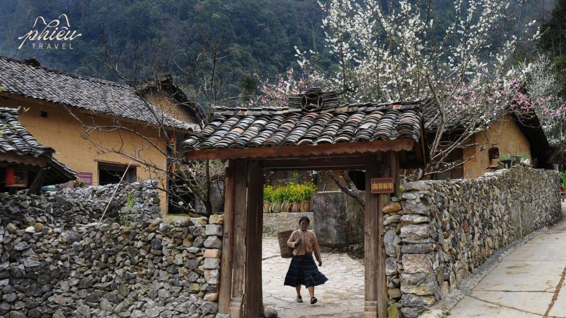
Dong Van – Cultural and Historical Heart with Old Quarter, Markets & the H’Mong King’s Palace
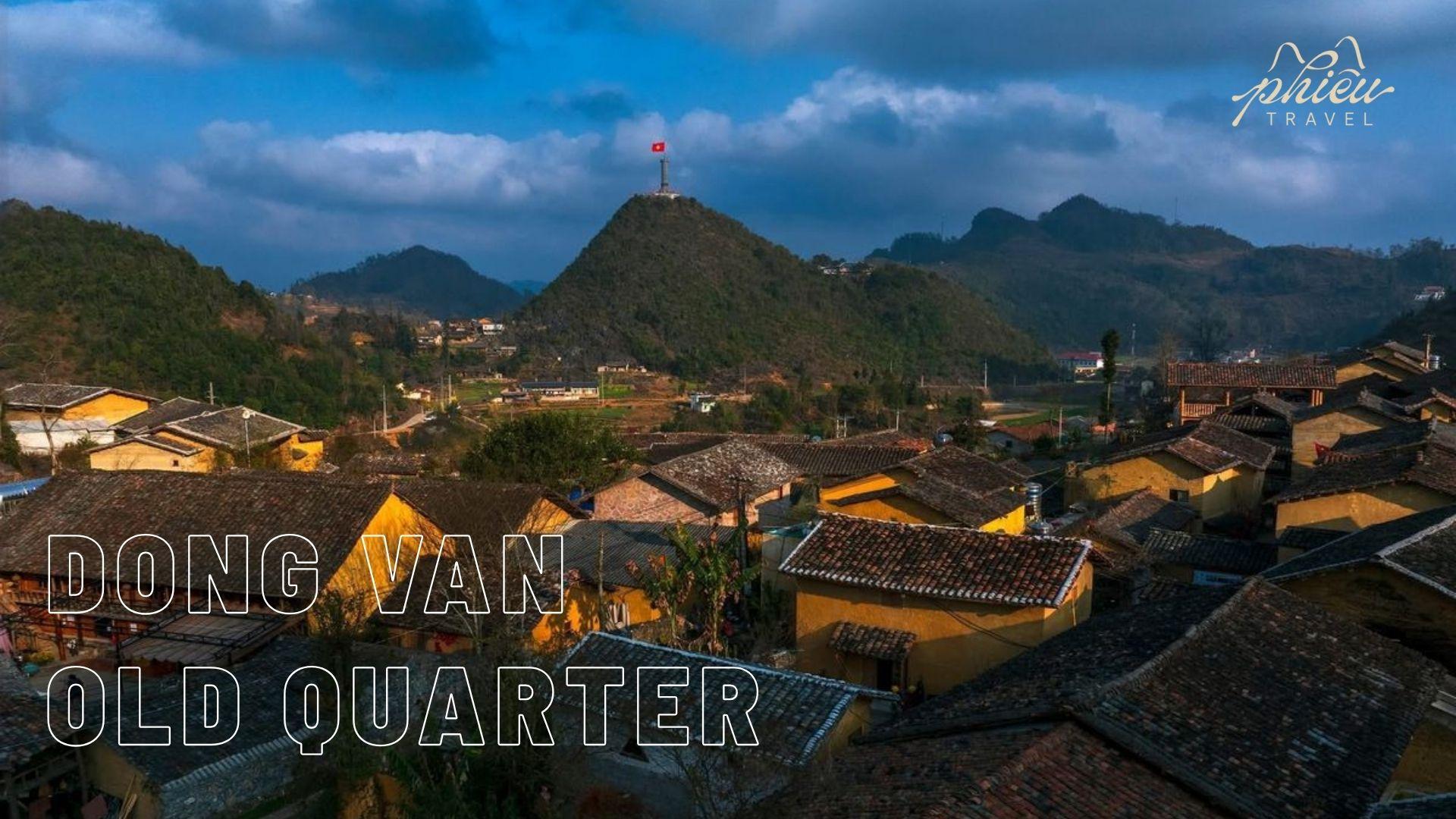
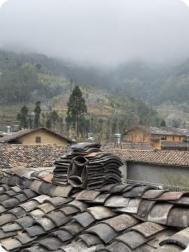
Situated at elevations between 1,000 and 1,600 meters within the Dong Van Karst Plateau, Dong Van Town rests quietly among limestone mountains, wrapped in cool air and morning mist. As part of the UNESCO Global Geopark, the town preserves deep historical imprints through stone houses with tiled roofs, wooden balconies, and architecture reflecting the cultural fusion of the Tay, H’Mong, Hoa, Nung and Dao peoples.
Dong Van Town rests quietly among limestone mountains, wrapped in cool air and morning mist.
Pao’s House is a well-known cultural landmark and filming location for the award-winning film “The Story of Pao”. Surrounded by rough stone walls and a sunken courtyard, the house showcases traditional H’Mong architecture and cultural values.
Pao’s House is a well-known cultural landmark and filming location for the award-winning film “The Story of Pao”
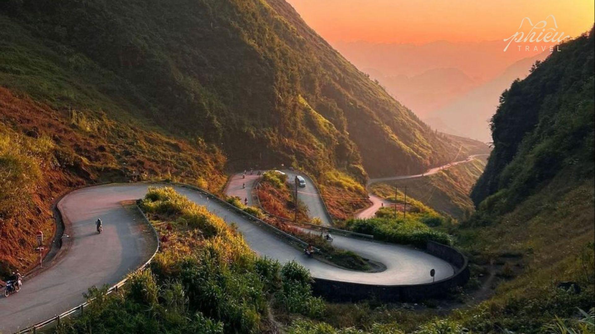
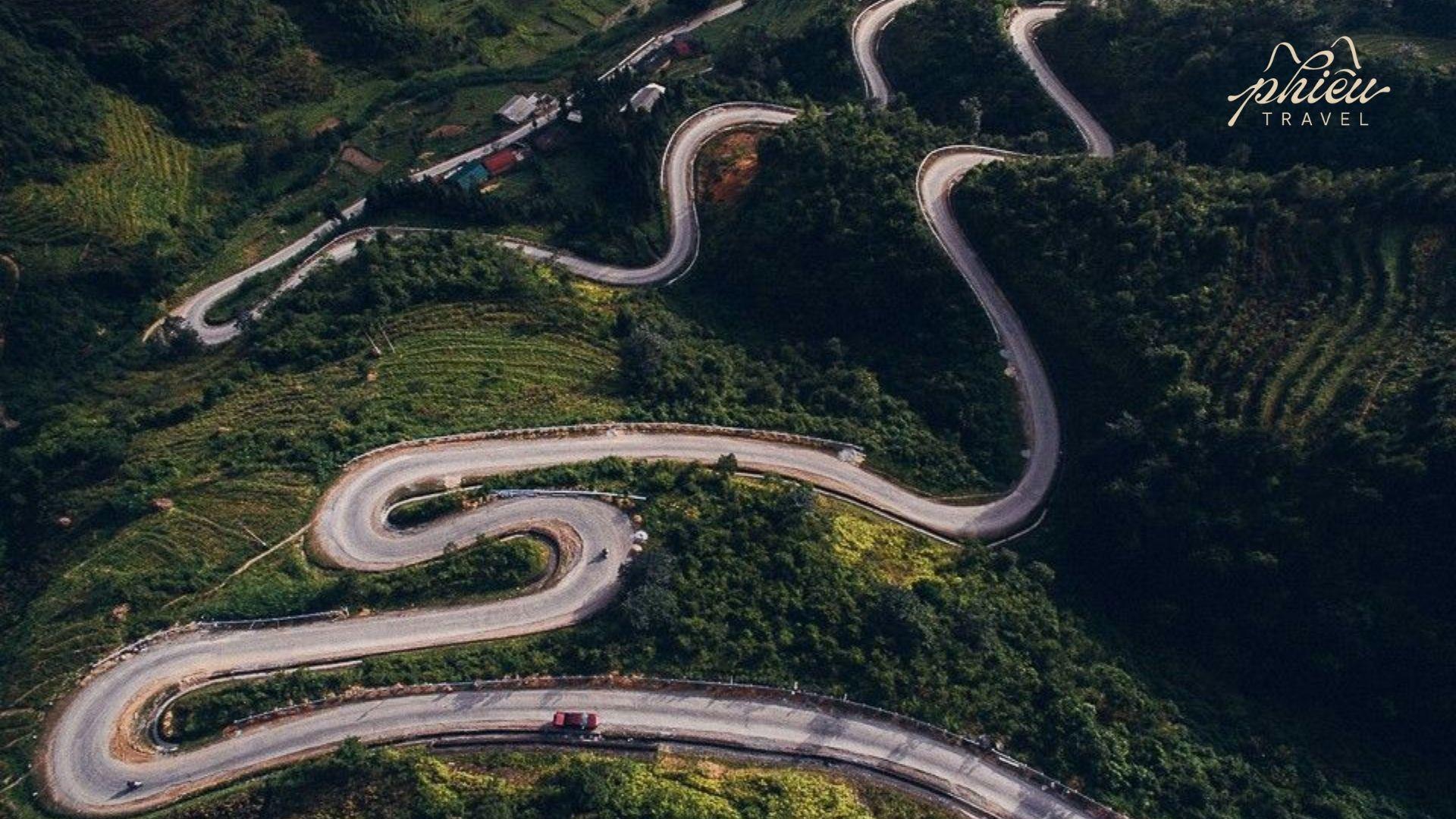
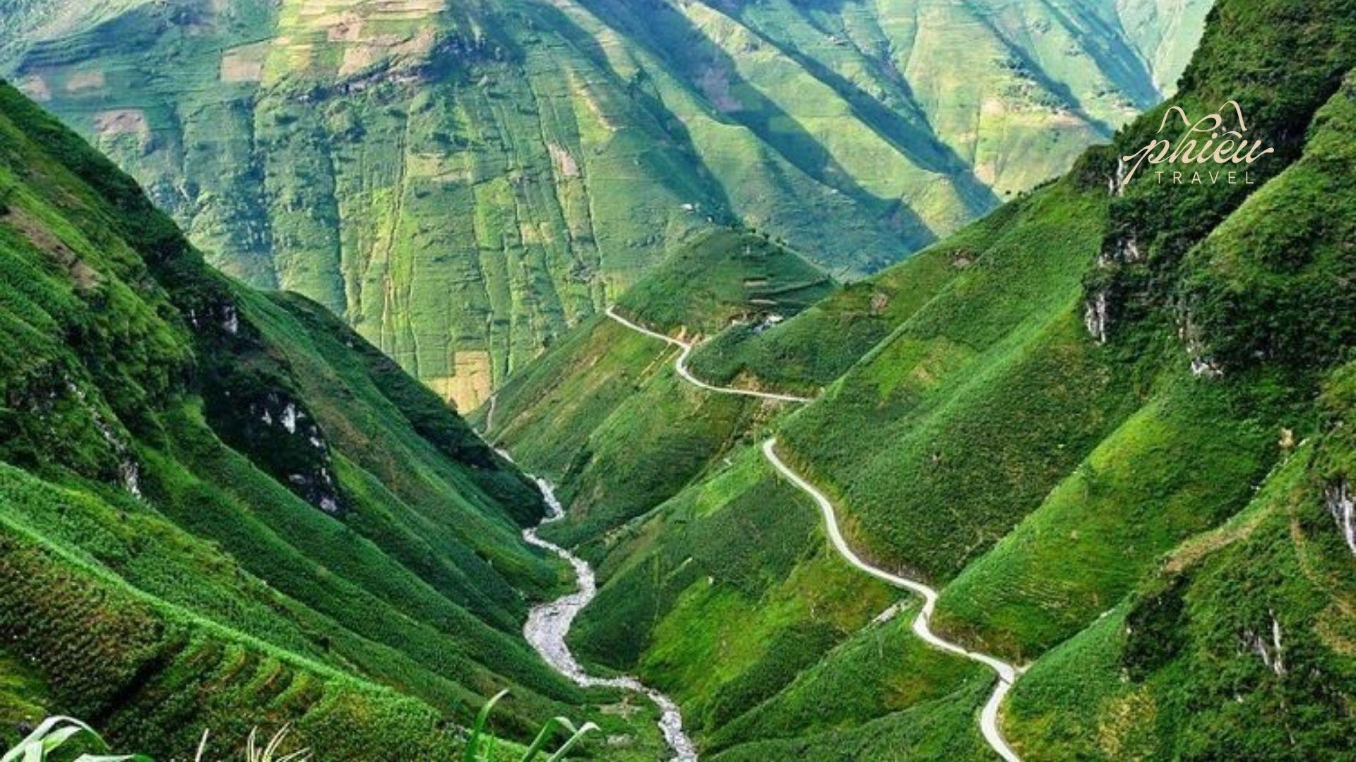
Chin Khoanh Ramp is a dramatic mountain road connecting Pho Cao and Sung La, featuring nine sharp hairpin bends carved into steep limestone slopes. It is one of the most thrilling and memorable sections of the Ha Giang Loop, especially for adventure enthusiasts.
Aerial view of the Chín Khoanh Ramp, a dramatic winding mountain road with tight curves cutting through lush green hills in Ha Giang.
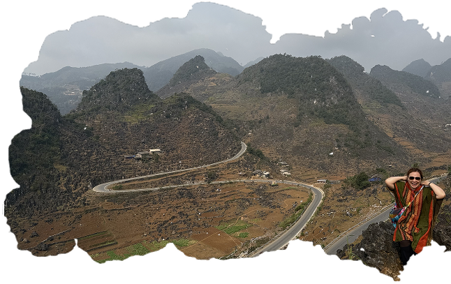
Tham Ma Pass is another iconic mountain stretch, famous for its S-shaped curve and imposing limestone cliffs. Winding through the Dong Van Plateau at high elevation, it offers breathtaking views, raw cultural encounters, and insight into the daily lives of the H’Mong people.
Tham Ma Pass is another iconic mountain stretch, famous for its S-shaped curve and imposing limestone cliffs.
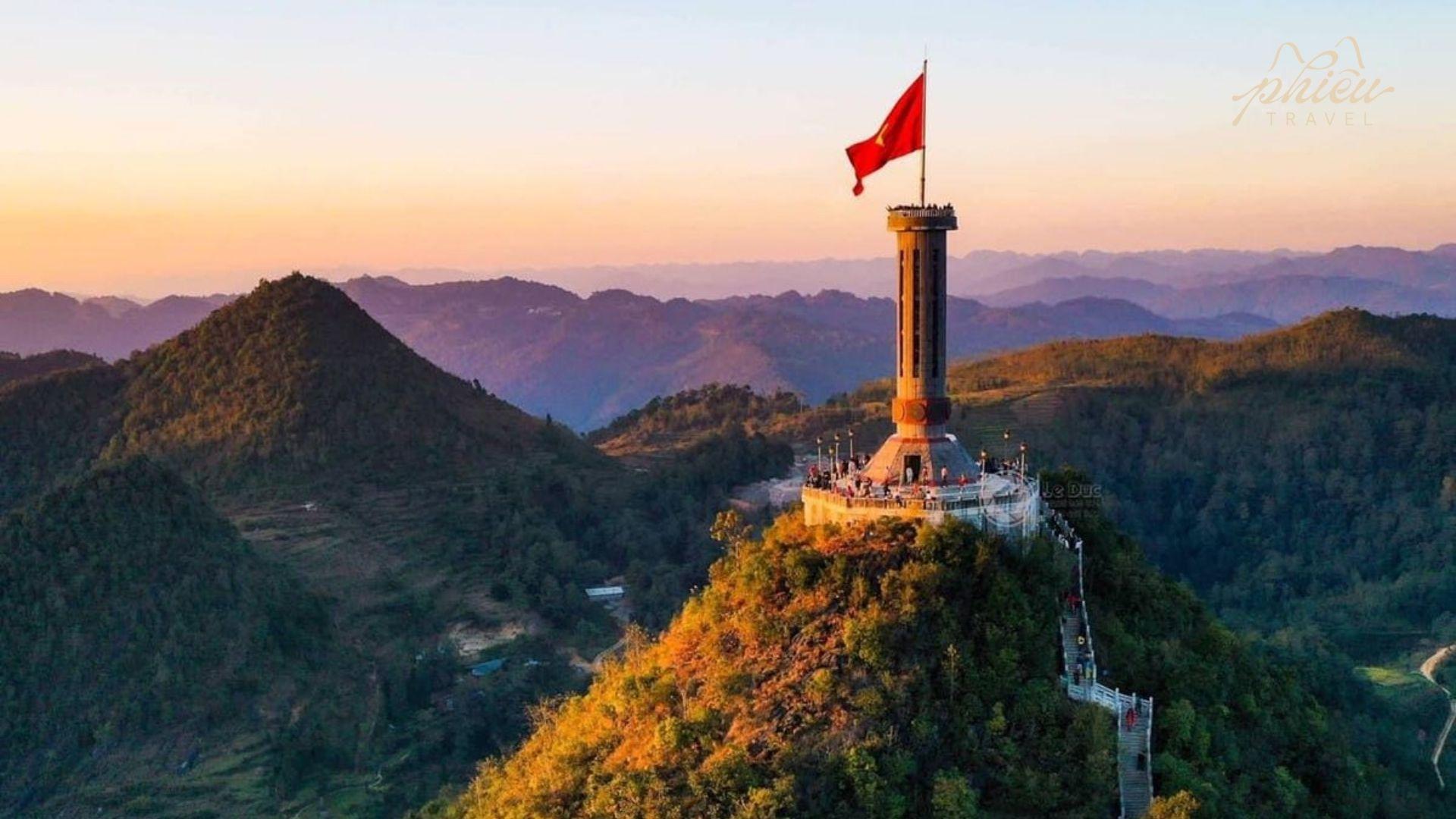
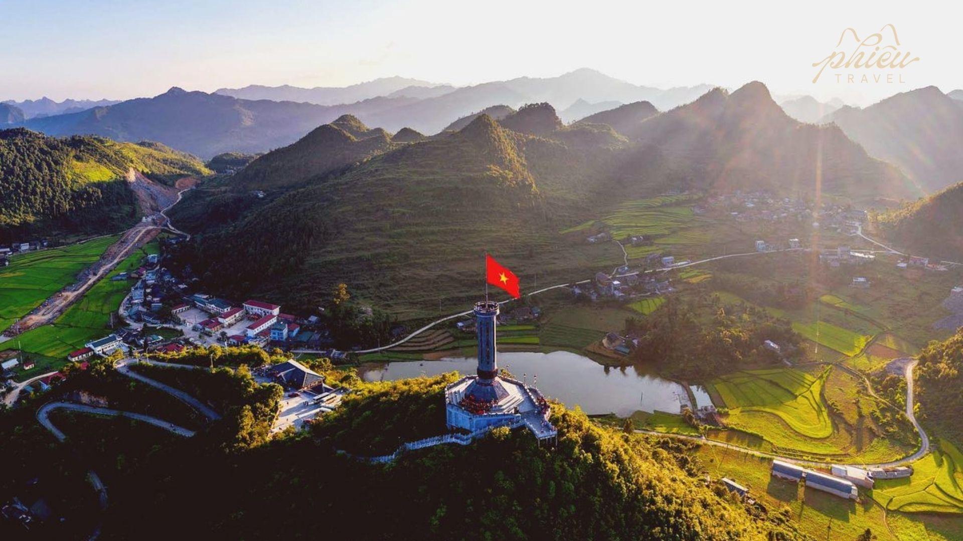
Lung Cu – Vietnam’s Northernmost Point & Lung Cu Flag Tower
Lung Cu, located at over 1,400 meters near the Chinese border, marks the northernmost point of Vietnam and is symbolized by the Lung Cu Flag Tower atop Dragon Mountain. The tower stands 33 meters tall, with a massive 9×6-meter national flag representing Vietnam’s 54 ethnic groups.
Its history dates back to the 11th century, with multiple restorations-the most recent in 2010-featuring Dong Son bronze drum motifs and stone carvings symbolizing Vietnamese culture.
Nearby villages such as Lo Lo Chai and Seo Lung preserve traditional lifestyles with rammed-earth houses, stone fences, and textile weaving, reflecting the rich cultural depth of Vietnam’s far north.
Marks the northernmost point of Vietnam and is symbolized by the Lung Cu Flag Tower atop Dragon Mountain.
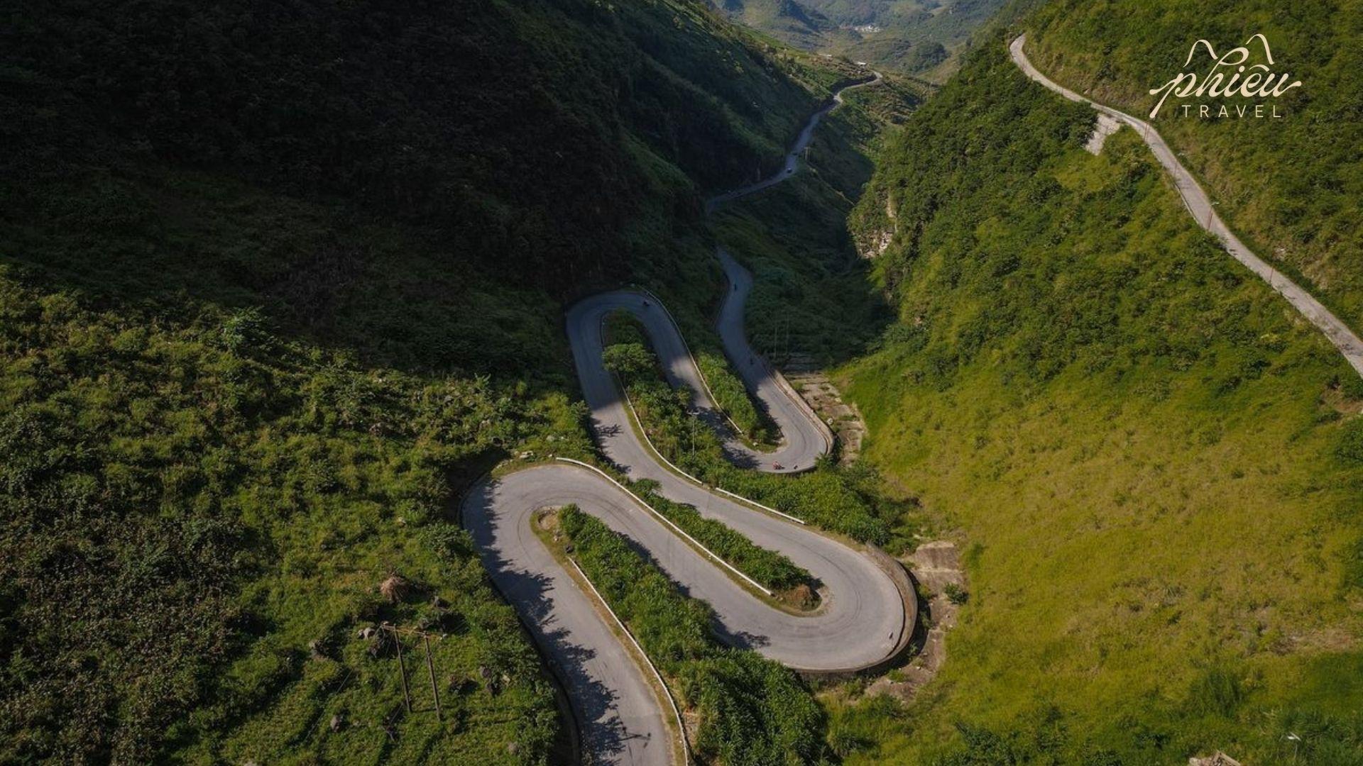
Ma Pi Leng Pass – Nho Que River
Ma Pi Leng Pass stretches approximately 20 km between Dong Van and Meo Vac at elevations around 1,500 meters. Constructed in the 1960s, it is the most challenging section of National Highway 4C, defined by sharp hairpin turns and sheer cliffs-an exhilarating experience for travelers.
Ma Pi Leng Pass stretches approximately 20 km between Dong Van and Meo Vac at elevations around 1,500 meters
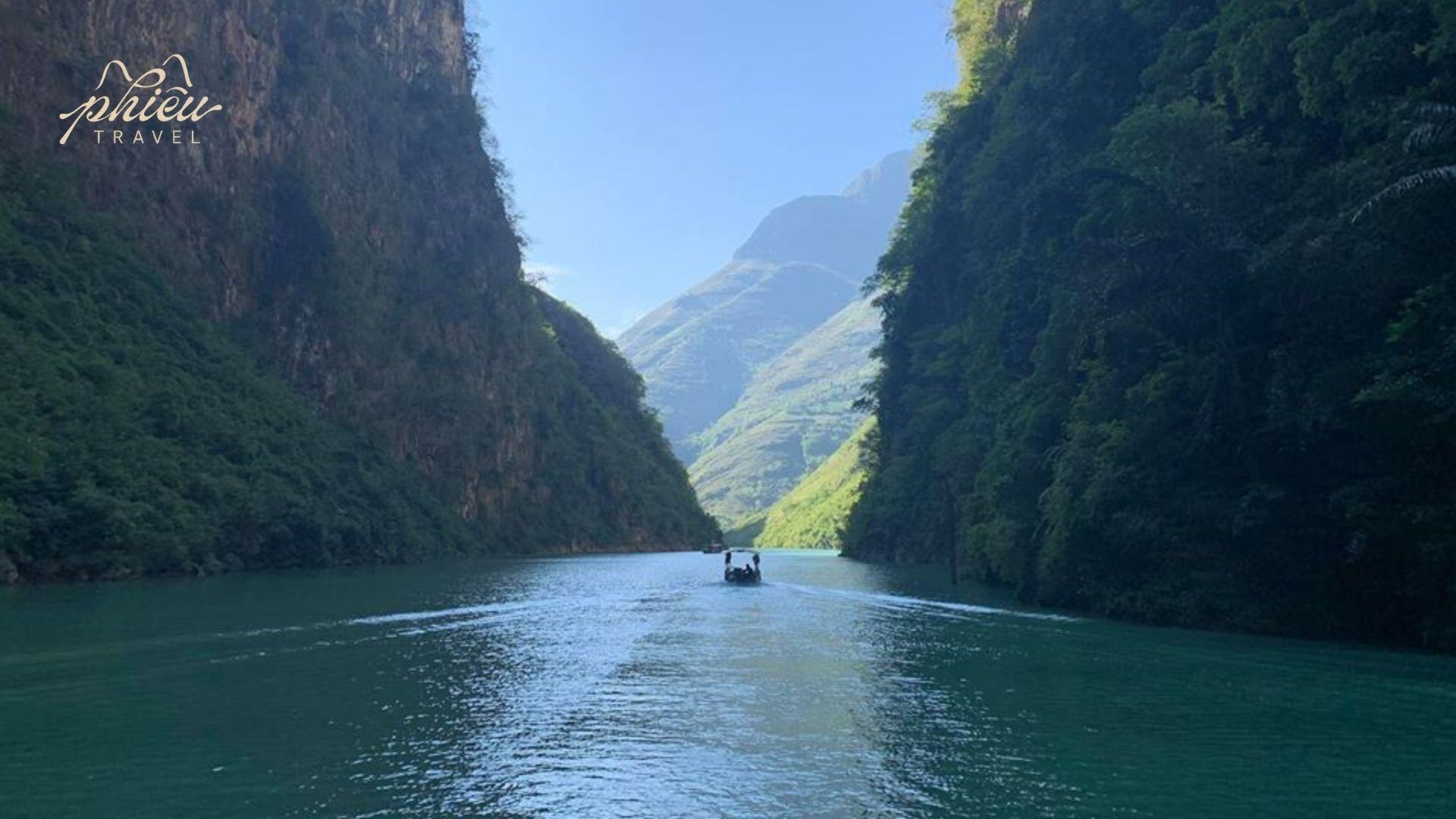
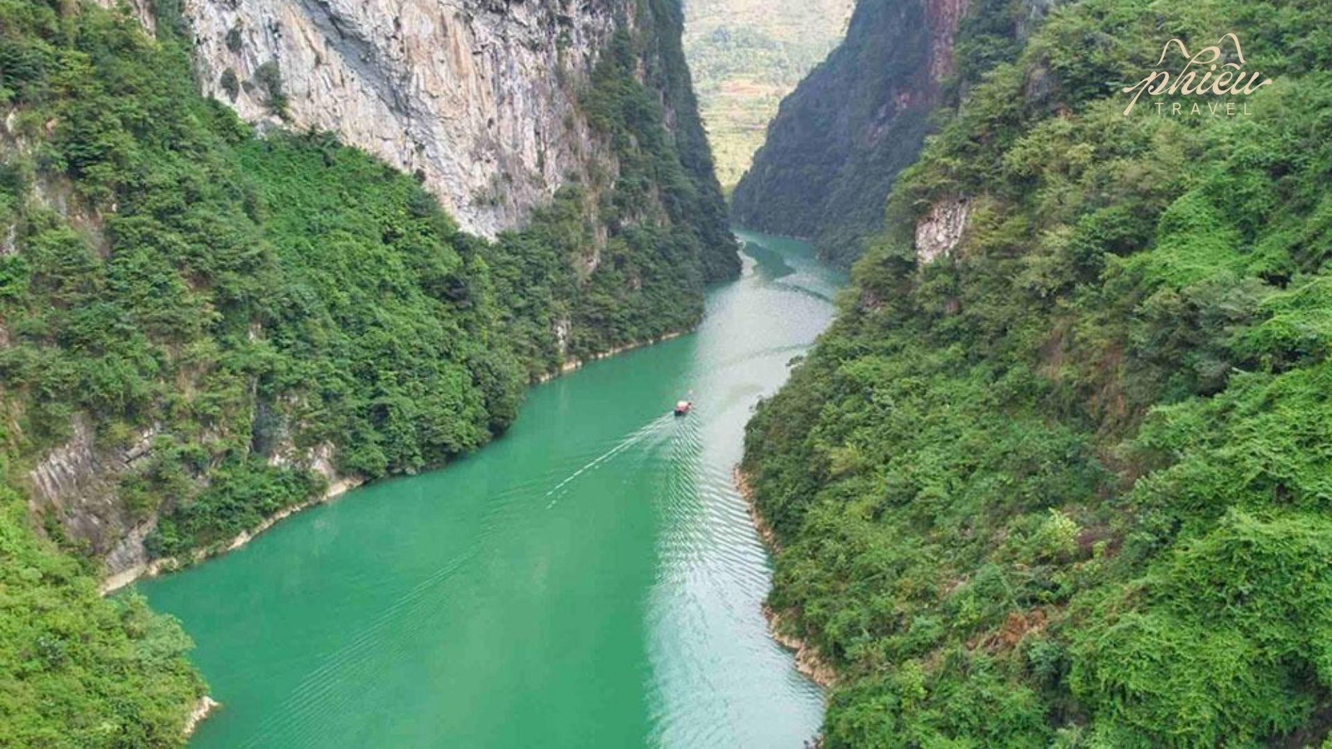
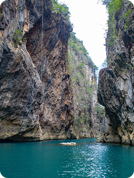
From the summit, the emerald-green Nho Que River winds through the Tu San Gorge-the deepest canyon in Southeast Asia-while layers of mountains extend endlessly into the distance, creating one of Vietnam’s most spectacular vistas. The best time to visit is from October to February, when weather conditions are dry and skies are clear.
The emerald-green Nho Que River winds through Tu San Gorge, Southeast Asia’s deepest canyon, with mountains stretching into the distance.
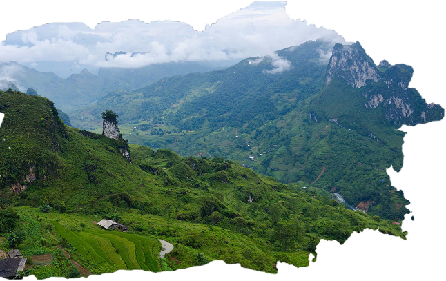
Meo Vac & Du Gia – Ethnic Villages, Waterfalls & Authentic Homestays
Located deep within the Dong Van Karst Plateau, Meo Vac is a dramatic destination characterized by winding mountain roads, towering limestone peaks, and rich ethnic diversity.
Meo Vac is a dramatic destination characterized by winding mountain roads
Approximately 70 km to the south, Du Gia offers a tranquil contrast with cool waterfalls, green rice fields, and gentle walking trails. Local homestays provide authentic experiences in stilt houses, family-style meals, and daily activities with residents, allowing travelers to embrace a slow pace of life closely connected to nature.
Local homestays provide authentic experiences in stilt houses, family-style meals, and daily activities with residents
Recommended Schedule for the Ha Giang Loop
Depending on available time and travel style, the Ha Giang Loop can be explored over 2, 3, or 4 days. Each option offers a different rhythm, balancing mountain scenery, ethnic villages, and cultural stops. Below are three suggested itineraries to help you visualize distances, highlights, and daily flow.
For travelers with more time, the 3-day 2-night itinerary offers a well-balanced experience between scenic riding and cultural immersion, with two overnight stays in ethnic villages.
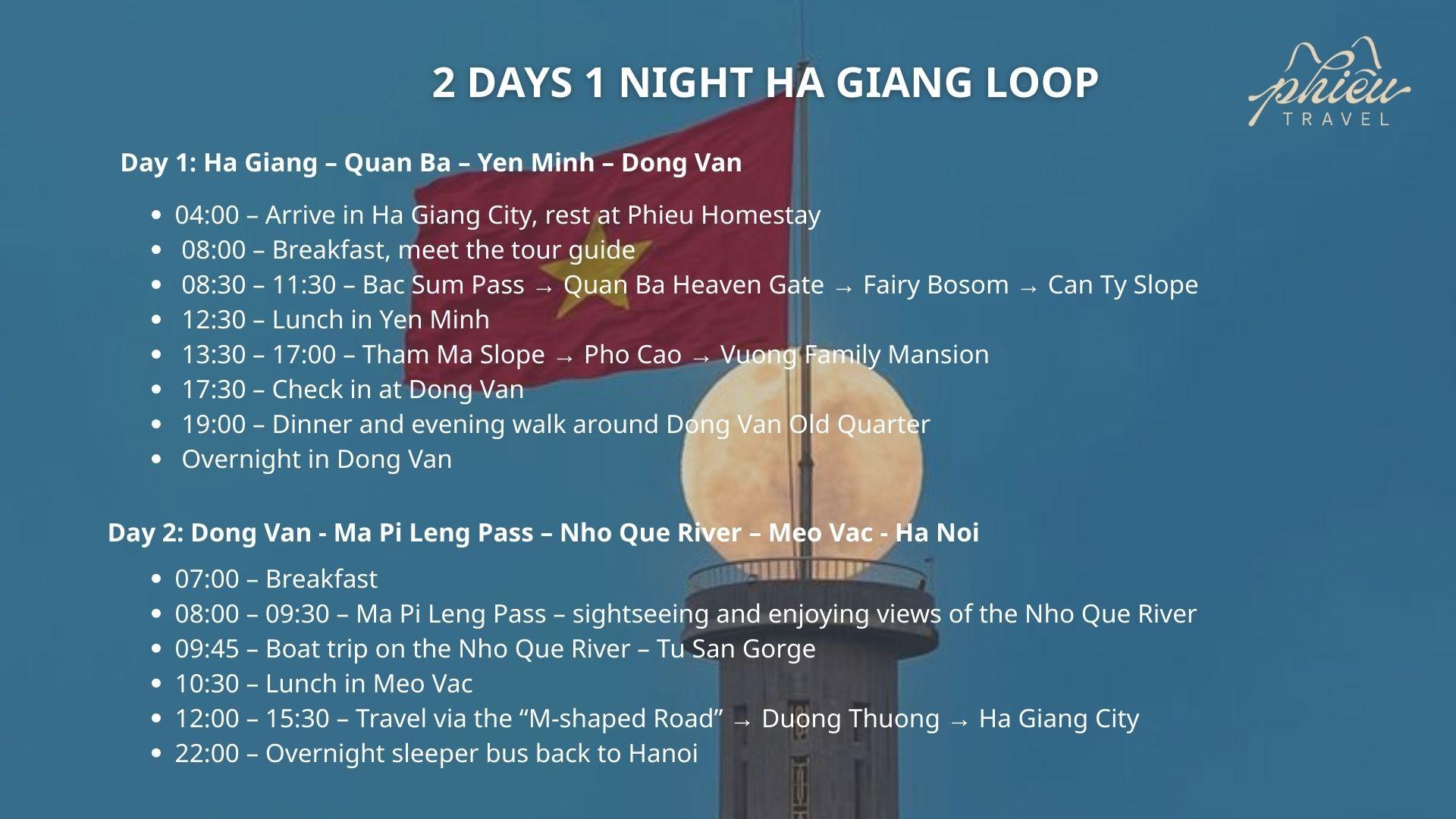
Day 1: Ha Giang – Quan Ba – Yen Minh – Dong Van
04:00 – Arrive in Ha Giang City by sleeper bus
Free rest, shower, and refreshment at Phieu Homestay
08:00 – Breakfast → Meet the tour guide → Itinerary briefing & Safety orientation
08:30 – 11:30 – Begin the Ha Giang Loop → Check-in at key highlights:
Four days and three nights allow you to experience the Ha Giang Loop in its entirety, combining dramatic landscapes, rich culture and peaceful ethnic villages.
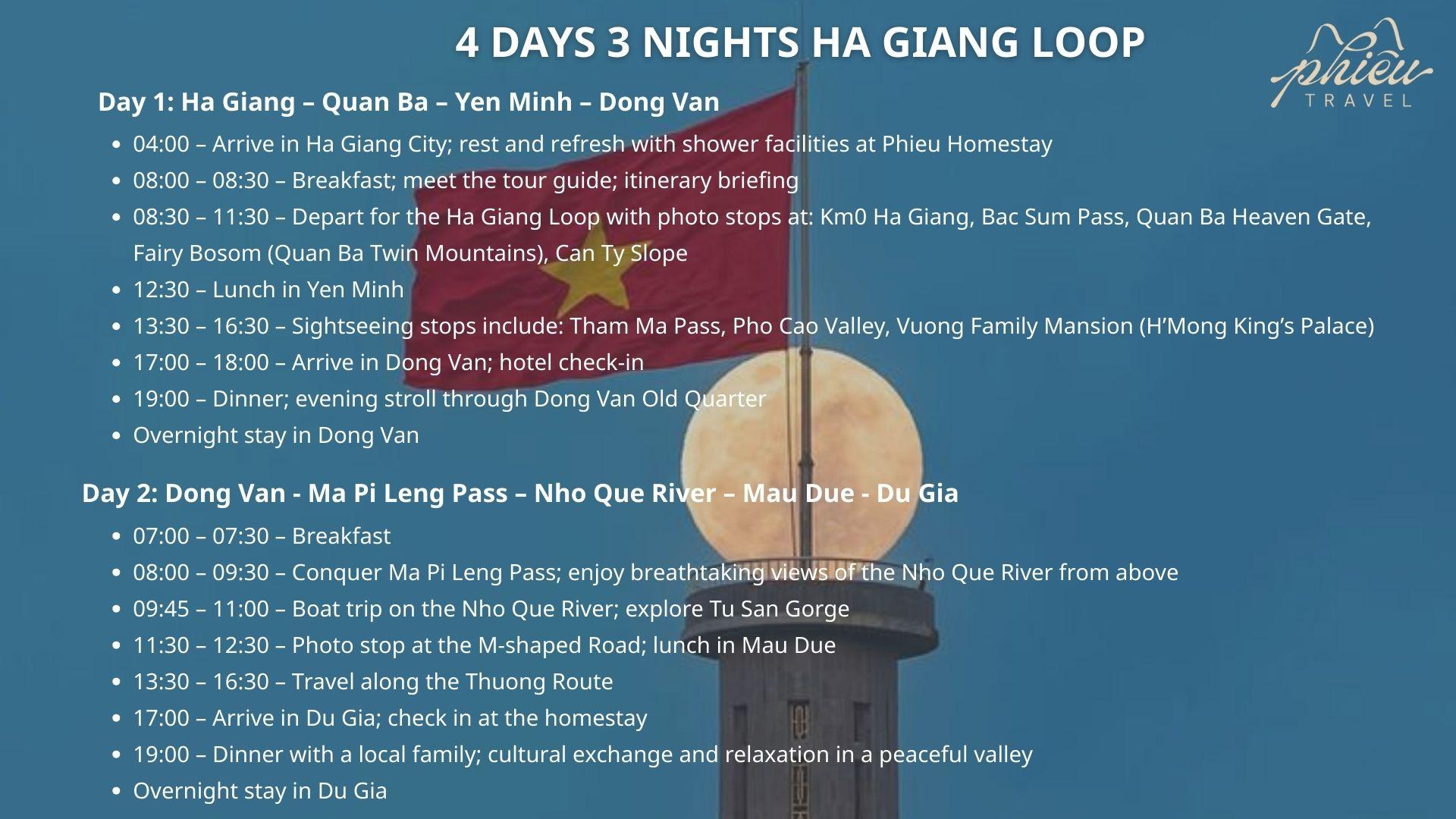
Day 1: Ha Giang – Quan Ba – Yen Minh – Dong Van
04:00 – Arrive in Ha Giang City
Rest and refresh with free shower facilities at Phieu Homestay
08:00 – 08:30 – Breakfast → Meet the tour guide → Itinerary briefing
08:30 – 11:30 – Begin the Ha Giang Loop → Check-in at key highlights:
Km0 Ha Giang
Bac Sum Pass
Quan Ba Heaven’s Gate
Twin Mountains (Fairy Bosom)
Can Ty Slope
12:30 – Lunch in Yen Minh
13:30 – 16:30 – Sightseeing along the route:
Tham Ma Pass
Pho Cao Valley
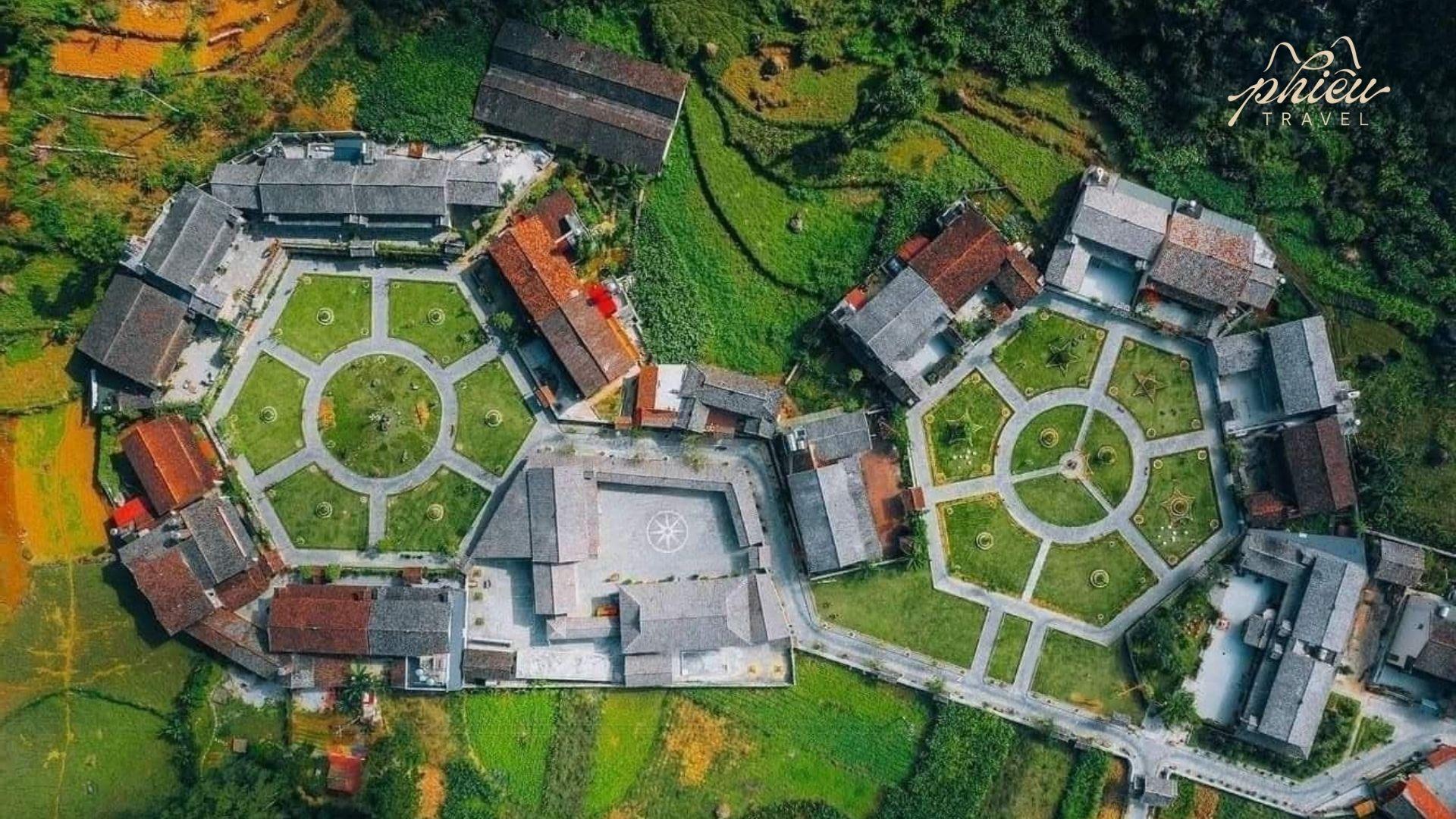
Visit the Vuong Family Palace (H’Mong King’s Residence)
17:00 – 18:00 – Arrive in Dong Van → Hotel check-in
19:00 – Dinner → Evening walk through Dong Van Old Quarter → Overnight in Dong Van
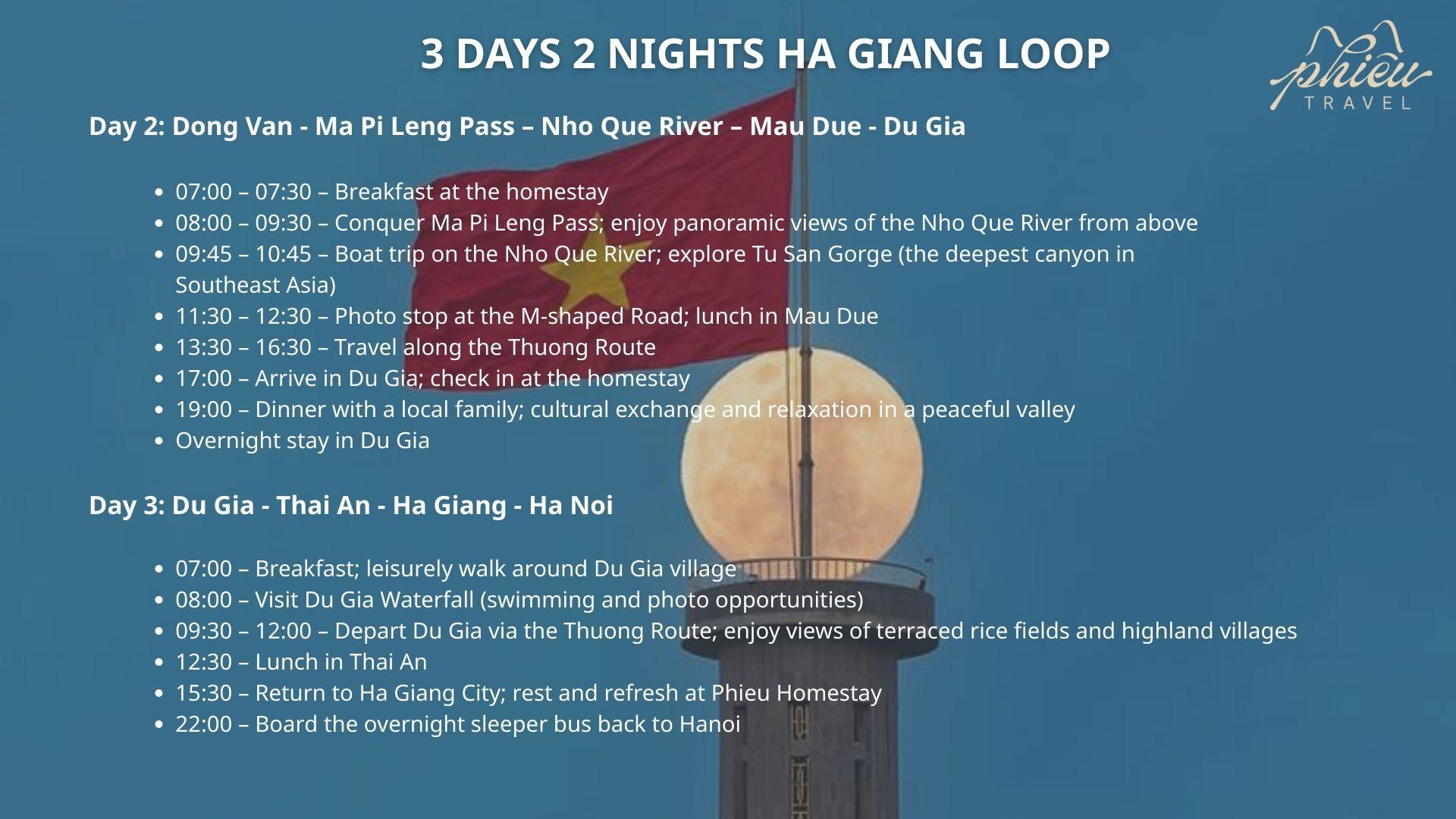
Day 2: Dong Van – Ma Pi Leng Pass – Nho Que River Cruise – Mau Due – Du Gia
07:00 – 07:30 – Breakfast
08:00 – 09:30 – Conquer Ma Pi Leng Pass
Enjoy panoramic views of the Nho Que River from above
09:45 – 11:00 – Boat cruise on the Nho Que River
Explore Tu San Gorge
11:30 – 12:30 – Check-in at the M-shaped road → Lunch in Mau Due
13:30 – 16:30 – Travel along the Thuong Road
17:00 – Arrive in Du Gia → Check in at the homestay
19:00 – Dinner with a local family → Cultural exchange and relaxation in the peaceful valley → Overnight in Du Gia
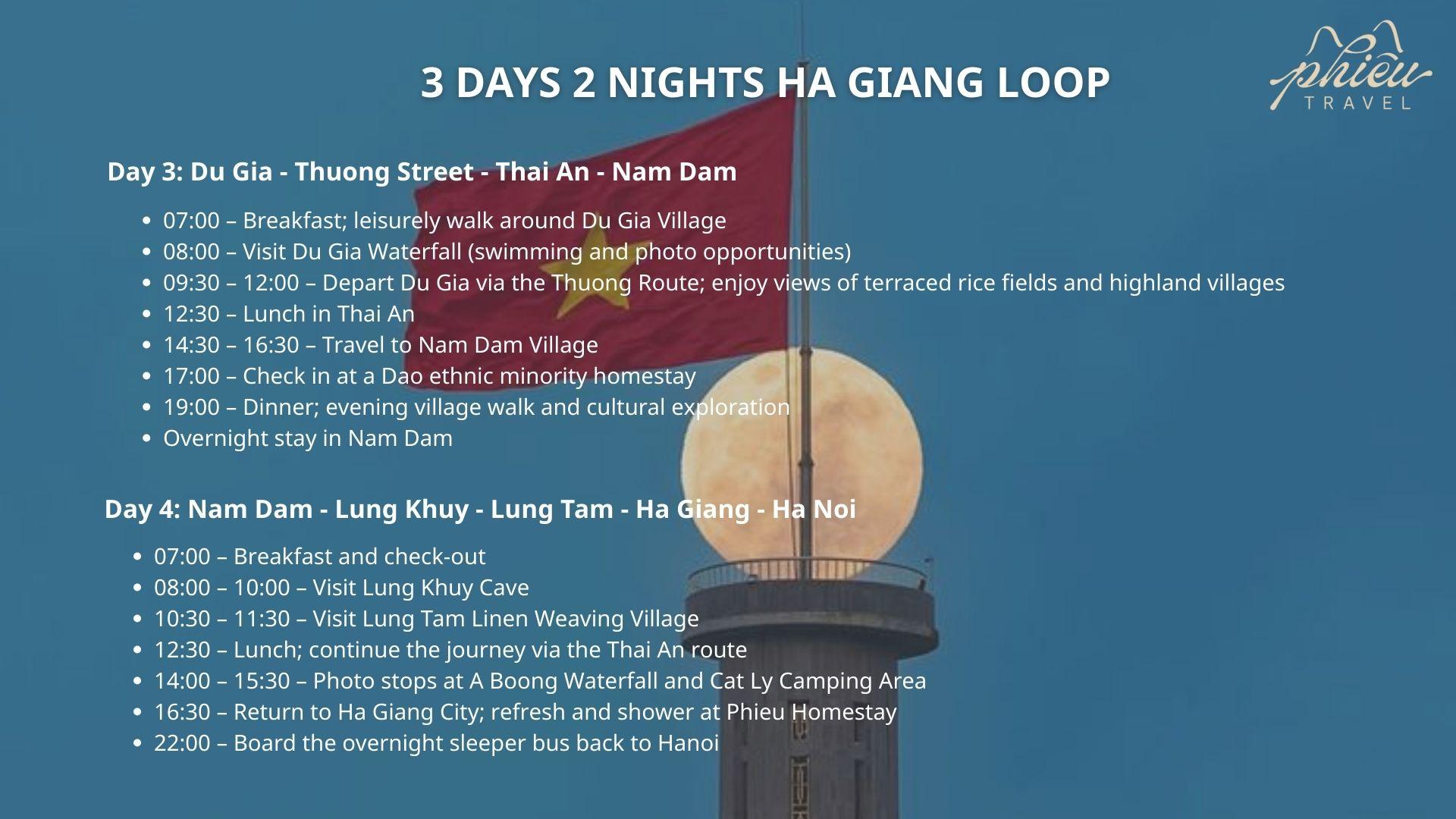
Day 3: Du Gia Village – Thuong Road – Thai An – Nam Dam
07:00 – Breakfast → Morning walk around Du Gia Village
08:00 – Visit Du Gia Waterfall (swimming and photography)
09:30 – 12:00 – Depart Du Gia via the Thuong Road → Admire terraced rice fields and highland villages
12:30 – Lunch in Thai An
14:30 – 16:30 – Travel to Nam Dam Village
17:00 – Check in at a Dao ethnic homestay
19:00 – Dinner → Evening village walk and cultural exploration → Overnight in Nam Dam
Day 4: Nam Dam – Lung Khuy Cave – Lung Tam – Ha Giang – Hanoi
16:30 – Return to Ha Giang City → Rest and shower at Phieu Homestay
22:00 – Board the sleeper bus back to Hanoi
Schedule for the Ha Giang Loop – 4 Days 3 NightsSchedule for the Ha Giang Loop – 4 Days 3 Nights
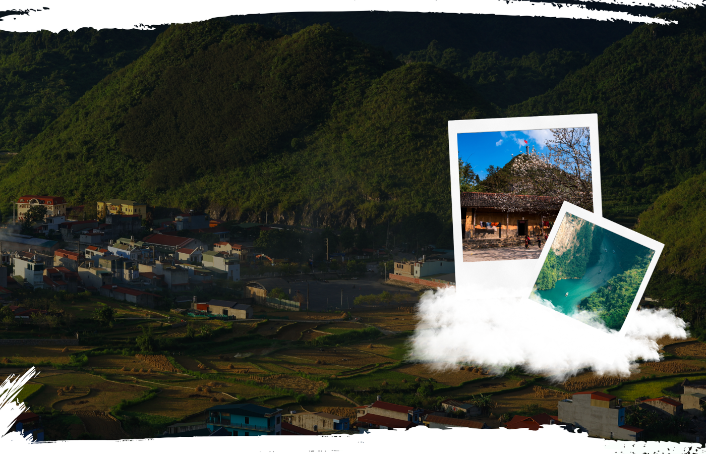
Travelogue – Knowledge & Stories from Real Journeys
The Travelogue section of PhieuTravel brings together authentic experiences, vivid stories, and valuable lessons drawn from real journeys through the northern highlands of Vietnam. More than a simple travel diary, it serves as a reliable knowledge resource for travelers who want to plan in detail, gain a deeper understanding of local culture, and optimize their experience on every route.
In Travelogue, you will find a wide range of content, including:
Transportation & Safety insights: Travelogue provides detailed guidance on routes and suitable means of transportation-from sleeper buses and self-riding motorbikes to easy rider tours-along with essential safety tips for mountain roads, weather conditions, terrain challenges, and emergency handling, ensuring a smooth and secure journey.
Highland culture & Cuisine:Each article tells stories about the customs, festivals, traditional clothing, crafts, and daily life of the H’Mong, Tay, Dao, Lo Lo, and other ethnic communities. Travelogue also introduces signature local dishes such as thang co, black chicken, five-color sticky rice, smoked meats, and corn wine, together with their cultural significance and tips on how to enjoy them fully.
Key destinations & Landscapes: Iconic winding roads, Ma Pi Leng Pass, Tu San Valley, the terraced rice fields of Yen Minh, Lo Lo Chai Village, Lung Cam, and towering mountain peaks are documented in detail, with practical travel tips, ideal check-in times, and the best viewpoints to help travelers plan a complete and rewarding journey.
Practical tips & Inspiring stories: Travelogue shares the best times to visit, ways to avoid crowds, lesser-known routes, and effective ways to interact with local communities. It also recounts emotionally rich experiences-from conquering challenging mountain passes to moments of awe inspired by nature and the warmth of local people-offering a vivid and realistic perspective on life in the highlands.
The Travelogue section of PhieuTravel brings together authentic experiences, vivid stories, and valuable lessons drawn
How to get to Ha Giang
Ha Noi is the most common starting point for trips to Ha Giang, with a distance of approximately 300 km. From here, travelers can choose to travel by sleeper bus, private car, or motorbike, depending on budget and comfort level for long-distance journeys.
Distance: Ha Noi – Ha Giang ~ 300 km
Common departure point: Ha Noi
Sleeper bus (Most popular option)
Evening departure – arrive in Ha Giang early the next morning
Travel time: 6 – 7 hours
Ticket price: 200,000 – 350,000 VND
Reputable operators: Hung Thanh, Hai Van, Bang Phan, Khai Huyen
Pick-up points: My Đinh Bus Station, Giap Bat Bus Station
Self-Driving car
Suitable for travelers with experience in long-distance driving
Many steep mountain passes and sharp curves near Ha Giang
Recommended to use a mid-size vehicle with good tires
Check weather conditions before departure
Motorbike
For experienced riders only
Travel time: 8 – 10 hours
Routes pass through rural areas with uneven terrain
Full protective gear required; start early in the day
Ideal for travelers who enjoy exploring less-crowded routes
Getting Around in Ha Giang
Motorbike rental: 150,000 – 500,000 VND/day (depending on bike type)
Easy Rider: Local driver included, safer and more comfortable
Particularly suitable for travelers unfamiliar with mountain roads
Support Services from Phieu Travel
Round-trip sleeper bus services from Ha Noi and northern provinces
Flexible options: Self-riding, easy rider, or car tours
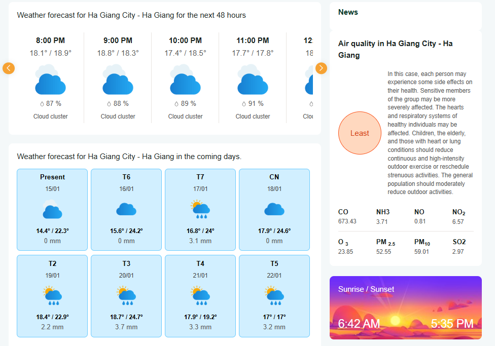
The Ha Giang Loop can be experienced year-round, but choosing the right time will make the journey safer and more visually rewarding. Each season in Ha Giang offers a distinct charm-from golden terraced rice fields during harvest season to buckwheat flower valleys and clear blue skies in the dry months. Below is an overview of weather conditions and standout experiences by month to help you plan your trip effectively.
October – November: The most beautiful period of the year, with ideal weather, stunning landscapes, and vibrant local festivals.
September: Rice harvest season, especially suitable for photography with golden terraced fields.
January – March: Clear highland atmosphere, cooler temperatures, and low rainfall.
Weather forecast for Ha Giang City in January
Join Phieu Travel and Conquer the Ha Giang Loop
Don’t miss our in-depth stories on travel experiences and highland culinary culture – including thang co, corn wine, and smoked meats -featured in our Traveloguesection.
The Ha Giang Loop takes you through rugged mountains, ethnic villages, and layers of history. More importantly, it is a journey into the most authentic essence of Vietnam. With a clearly structured route system, detailed tours, in-depth travel guidance, and the dedicated companionship of Phieu Travel, the Ha Giang Loop becomes a complete and unforgettable experience.
Ha Giang Loop – More than just a journey
THE BEST OPTIONS
While every road in Ha Giang leads to a masterpiece, Phieu Travel has curated a journey through its most quintessential destinations for a truly complete experience. This is not just a list of famous places, but the soul of the land itself: from legendary, dream-worthy passes to serene villages holding deep cultural stories.
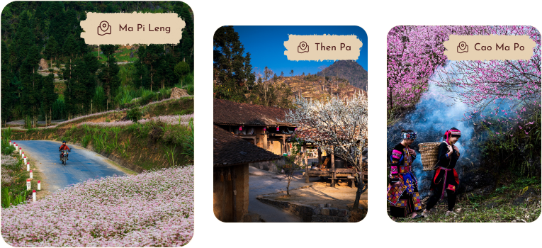
Reigning as the ‘King of Passes,’ Ma Pi Leng presents the ultimate challenge on Vietnam’s famed Happiness Road. It tests every rider with treacherous curves and sheer cliffs. The reward from its summit is an unforgettable, panoramic vista of the magnificent Tu San Canyon and the winding, emerald Nho Que River.
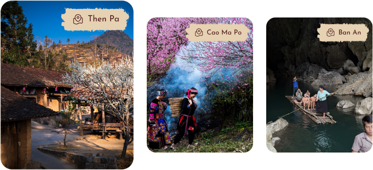
Nestled peacefully beneath the sacred Lung Cu Flagpole, Then Pa is a H’mong village preserving the plateau’s pristine, rustic beauty. The village captivates with its traditional rammed-earth houses, humble stone fences, and a tranquil atmosphere, feeling completely set apart from the modern world’s hustle and bustle.
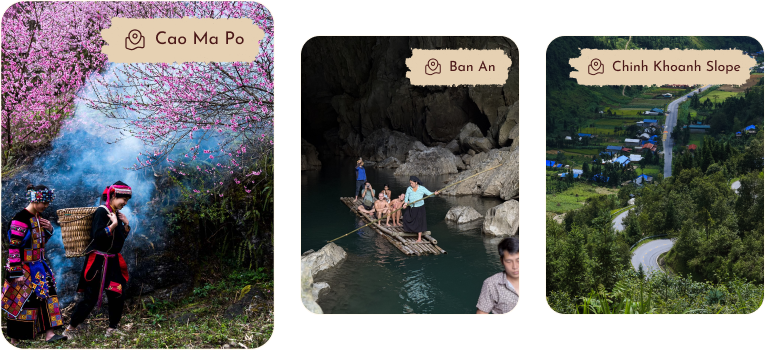
Cao Ma Po
Perched above 1500m, Cao Ma Po is a pristine border commune in Quan Ba, an enigmatic destination of clouds and tranquil hillsides. With seasons of brilliant cherry blossoms and rare opportunities for ice hunting, it offers a journey of profound discovery and an authentic connection to untouched nature and culture.
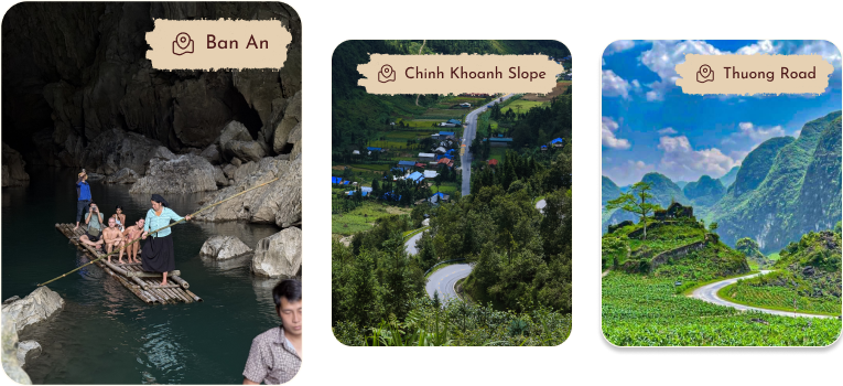
Ban An Stream
Known as Ha Giang’s ‘Tuyet Tinh Coc,’ Ban An stream is a secret oasis in Yen Minh, captivating visitors with its crystal-clear, mirror-like emerald surface. Nestled securely amidst virgin forests and cliffs, it offers a sanctuary of absolute tranquility an ideal retreat to leave worries behind and reconnect with nature.
Vehicle standards for tour guests: 01 double bed mobile palace or 02 regular beds (Surcharge for upgrading ticket class according to customer request)
Pick-up location: The bus company has shuttle buses within Hanoi city. Airport pick-up is available according to the night or day schedule (For night trips, pick-up at the airport; For day trips, please travel 1.5 KM from the airport to Noi Bai - Lao Cai Highway Intersection)
DAY 1: HA GIANG - QUAN BA - YEN MINH - LO LO CHAI (155KM)
4:00: The bus will drop you off at the hotel. You check in and wait in Ha Giang City
7:30: The tour guide receives the group, you depart from Ha Giang City to Dong Van Stone Plateau
8:00: Check in KM 0 -> You have breakfast (Veil noodle soup Km12) - Departing from Ha Giang City to Dong Van, you will visit the following locations: Quan Ba Heaven Gate; Fairy Twin Mountain; Lonely Nghien Tree and beautiful check-in locations on the way. (Note: You can stop to take photos freely)
12:30 - 13:00: Have lunch at Moc Quan, Yen Minh town
14:00: Move from Yen Minh to Dong Van: on the way, you will stop by Doc Tham Ma; Nha Pao; Nha Vuong; Lung Cu Flagpole; Visit Lo Lo Chai village
17:00-18:00: Check in homestay in Lo Lo Chai - Lung Cu
19:30: Have dinner and cultural exchange at Homestay
DAY 1: HA GIANG – BAC SUM PASS – QUAN BA HEAVEN’S GATE – TWIN MOUNTAINS – YEN MINH – VUONG’S FAMILY PALACE – DONG VAN (155KM)
4:00 AM: The bus arrives in Ha Giang. The tourists check- in and take a rest for a few hours at Phieu Homestay – Ha Giang City.
8:00 AM: Check out and enjoy breakfast at the homestay. After breakfast, the tour guide meets the group. If you ride a motorbike yourself, you’ll have a brief training session before the tour officially starts.
Journey highlights:
Departure from Ha Giang City toward Dong Van Karst Plateau.
Check-in at: Bac Sum Pass, Quan Ba Heaven's Gate, Fairy Twin Mountains, and Can Ty Slope with stunning views — lush green hills and majestic mountains.
12:30–1:00 PM: Lunch in Yen Minh town. Continue the journey through Tham Ma Slope, Pho Cao Valley, and Vuong's Family Palace — a historical highlight rich with fascinating stories.
NIGHT 1: Overnight Stay in Dong Van town.
5:00–6:00 PM: Check-in at a Homestay/Hotel in Dong Van town.
7:00 PM: Enjoy dinner and engage in cultural exchange activities at Dong Van Old Quarter.
DAY 2: DONG VAN – MA PI LENG PASS – NHO QUE RIVER – M-SHAPED CURVE – THUONG ROAD – DU GIA
7:30 AM: After breakfast, depart from Dong Van town.
Visit Ma Pi Leng Pass — one of Vietnam’s "Four Great Passes", offering spectacular views of Nho Que River from above.
9:45 AM: Take a boat trip on the Nho Que River, admire the Tu San Alley - an incredible gorge blending with the emerald river below.
Then, proceed to check-in at the M-shaped Curve, then enjoy lunch in Mau Due. Optionally, visit the Lung Ho viewpoint (if time permits; otherwise, it can be scheduled for the next morning).
NIGHT 2: Overnight stay at a homestay in Du Gia.
5:00 PM: Check-in at Du Gia Homestay.
7:00 PM: Enjoy dinner and engage in cultural exchange activities at the homestay.
DAY 1: HA GIANG – BAC SUM PASS – QUAN BA HEAVEN'S GATE – TWIN MOUNTAINS – YEN MINH – VUONG FAMILY PALACE – DONG VAN (155KM)
4:00 AM: The bus will drop tourists off at the hotel. The tourists check-in and receive the rooms, then take a rest for a few hours at Phieu Homestay in Ha Giang City.
8:00 AM: After checking out, the tourist enjoys breakfast at the homestay. Following breakfast, the tour guide will meet the group. For those participating in the self-driving tour, the guide will provide a brief training session and an introduction to the Ha Giang Loop journey.
The tourists will depart from Ha Giang City to the Dong Van Karst Plateau. Along the way, they will stop to check in and visit some famous locations: Bac Sum Pass, Quan Ba Heaven's Gate, Fairy Twin Mountains, and Can Ty Slope. Each of these sites offers stunning views and inspiring natural scenery that resembles a painting, featuring lush green hills and towering mountains.
12:30 PM - 1:00 PM: Enjoy lunch in Yen Minh town. Afterward, continue your journey through Tham Ma Pass and Phu Cao Valley, then visit the Vuong's Palace (Dinh Thự Vua Mèo), which is a highlight of the trip filled with fascinating historical stories.
NIGHT 1: Overnight stay at Dong Van Town
5:00-6:00 PM: Check-in at a Homestay/Hotel in Dong Van Town.
7:00 PM: Enjoy dinner and engage in cultural exchange activities at Dong Van Old Quarter.
DAY 2: DONG VAN – MA PI LENG – NHO QUE RIVER – M-SHAPED CURVE – DUONG THUONG – HA GIANG CITY – HANOI
7:30 AM: After breakfast, we depart from Dong Van Town to Ma Pi Leng Pass — one of the four most famous passes in Vietnam. From the top of the pass, we can admire the entire serene landscape of the peaceful Nho Que River.
9:45 AM: Take a cruise on the Nho Que River. Looking up, you will see the majestic Tu San Canyon blending with the emerald green color of the river, creating a breathtaking natural landscape.
10:30 AM: Proceed to Meo Vac for lunch, then check-in at the M-shaped Curve, followed by travel along Thuong Road to Thai An and back to Ha Giang City.
3:30-4:00 PM: Finish the tour. A free shower is available at our homestay.
Here’s what our clients say about us: their testimonials reflect our commitment to exceptional service.
Unforgettable Ha Giang Adventure
A fantastic tour! The views were incredible and every stop felt authentic and special. Our guide was kind, informative, and always helpful. I’ll never forget the winding roads and peaceful villages. Would definitely do it again!
Sarah L.
Australia
Breathtaking Journey Through Ha Giang The tour was amazing! Stunning landscapes, friendly local people, and a great guide who made everything smooth and fun. Riding through the mountains was the highlight of my trip to Vietnam. Highly recommended!
If you choose a motorbike with a driver, then no, you do not need a motorbike license to experience the Ha Giang Loop. You will be riding as a passenger.
If you choose a motorbike with a driver, then no, you do not need a motorbike license to experience the Ha Giang Loop. You will be riding as a passenger.
The tour price covers meals, entrance fees, and the Nho Que River boat trip, but excludes personal expenses or private room surcharges.
GALLERY
From our passionate guides to our friendly hosts, every member of our team brings heart and authenticity to your journey. We’re proud to be locals sharing our home with you.