
Vietnam’s remote northern province of Ha Giang hides a natural wonder that has captivated adventurous travelers for years the magnificent M-shaped Curve. This engineering marvel, carved into limestone mountains, forms one of the most photographed stretches of road in Southeast Asia. As you navigate the hairpin turns that create its distinctive M pattern, you’ll be rewarded with breathtaking panoramic views of emerald valleys below. Join Phieu Travel as we explore this iconic landmark on the Ha Giang Loop, sharing insider tips to help you experience the perfect blend of adrenaline and awe at one of Vietnam’s most photogenic destinations.

1. What is the M-Shaped Curve?
The M-shaped Curve stands as one of Vietnam’s most spectacular road features, defining a stretch of highway that forms a perfect letter “M” when viewed from above. This natural roller coaster winds through the dramatic karst landscape of Ha Giang province, hugging steep mountainsides as it connects remote villages. The road’s tight switchbacks create the distinctive M shape, allowing vehicles to gradually ascend or descend the otherwise impassable terrain. Its engineering elegance combined with the surrounding natural beauty has made it a bucket-list destination for adventurous travelers exploring northern Vietnam.
1.1 Geographical Features
The M-shaped Curve isn’t just a pretty zigzag on a map it’s a masterclass in mountain engineering nestled in Ha Giang’s limestone karst landscape. Located between 1,000-1,200 meters above sea level, the curve cuts through mountains formed over 400 million years ago during the Devonian period. Dramatic limestone cliffs rise on one side, while steep drops fall away on the other, opening to sweeping valley views. The surrounding geology features exposed karst formations, creating a dramatic backdrop that changes colors throughout the day as sunlight shifts across the mountainsides.
The curve itself spans approximately 800 meters in length and navigates an elevation change of about 100 meters through its series of switchbacks. What makes it particularly remarkable is how perfectly the road follows the natural contours of the mountain, creating sharp, angular turns that, when viewed from certain vantage points, form the unmistakable “M” shape. Lush vegetation clings to the surrounding slopes, with hardy pine trees and shrubs surviving the rocky terrain, while seasonal mists often swirl through the valleys below, adding to the ethereal atmosphere.
1.2 Cultural and Local Legends
Local H’mong and Dao people have woven rich stories around the M-shaped Curve, seeing it as more than just a road. One popular legend tells of a mountain spirit who drew the letter M as a protection symbol for travelers crossing this dangerous terrain. Another tale suggests the curves represent the silhouette of a sleeping dragon whose back forms the road’s distinctive pattern. These stories reflect the deep spiritual connection between ethnic minorities and Ha Giang’s dramatic landscape.
For generations, local communities used primitive footpaths along these same contours before modern construction. When the road was built during the 1960s as part of the larger “Happiness Road” project, it required immense manual labor from local workers using basic tools to carve into the mountainside. Villagers tell stories of their parents and grandparents spending years working on this section, carrying rocks by hand and using simple pulley systems. Today, the curve serves as both a vital transportation link and a symbol of human determination to connect isolated communities across Ha Giang’s challenging terrain.

2. Where is the M-Shaped Curve Located?
The M-shaped Curve sits within the broader Ha Giang Loop, a 350-kilometer circuit through Vietnam’s northernmost province. While some confusion exists about its exact location, the most famous and photographed M-shaped curve lies along Provincial Road 182, specifically between Meo Vac and Mau Due towns. This particular section falls approximately 20 kilometers west of Meo Vac, in a remote area surrounded by limestone peaks and valleys. Another notable M-shaped formation appears at Bac Sum Pass, about 45 kilometers from Ha Giang City when traveling toward Quan Ba district.
2.1 Map, GPS, and Ha Giang Loop Context
The iconic M-shaped Curve is nestled within the larger Ha Giang Loop, forming a critical link in this famous motorcycling route. The primary M-shaped formation most travelers seek is located at coordinates 23°11’22.5″N 105°24’07.1″E, between Meo Vac and Mau Due districts. This places it roughly 170 kilometers from Ha Giang City when following the traditional clockwise loop route. A secondary, less dramatic M-formation can be found at Bac Sum Pass (coordinates 23°04’42.2″N 104°58’43.7″E), which many travelers encounter on their first day leaving Ha Giang City.
When navigating to the main M-shaped Curve, most travelers rely on offline maps as cellular service remains spotty throughout the region. Platforms like Maps.me and Google Maps (downloaded for offline use) typically mark the curve as a point of interest. Within the context of the full Ha Giang Loop, the primary M-shaped Curve typically falls on day two or three of a standard 3-4 day itinerary. It sits between other famous attractions including the Dong Van Karst Plateau (a UNESCO-recognized geopark) and the legendary Ma Pi Leng Pass, making it a natural stopping point when traveling between these major highlights.
2.2 How to Access: Routes and Landmarks
Accessing the M-shaped Curve depends on your starting point and chosen direction around the Ha Giang Loop. Most travelers begin from Ha Giang City, traveling clockwise toward Dong Van and Meo Vac before encountering the curve. From Meo Vac town, follow Provincial Road 182 westward for approximately 20 kilometers, watching for signs indicating “Đèo M” (M Pass). Look for a small roadside pull-off area where multiple vehicles often stop for photographs this typically marks the best viewing spot for the curve below.
Several distinctive landmarks help confirm you’re approaching the correct location. About 500 meters before reaching the curve’s upper viewpoint, you’ll pass a small village with colorful Hmong houses. The road then begins a significant descent with multiple switchbacks. Another reliable landmark is a towering limestone karst formation resembling a seated Buddha that appears on your left just before the main curve begins. For those exploring by motorcycle, the road surface noticeably improves around the M-shaped section compared to other parts of the loop, with recently paved asphalt and clear road markings making the tight turns easier to navigate.

3. Why is the M-Shaped Curve Famous?
The M-shaped Curve has risen to fame as one of northern Vietnam’s most photographed locations, capturing the imagination of travelers worldwide. Its perfect geometric pattern carved into rugged mountain terrain creates a mesmerizing contrast between natural landscape and human engineering. Social media has amplified its popularity, with drone footage showcasing its perfect symmetry from above generating millions of views across platforms like Instagram and YouTube. Beyond its visual appeal, the curve represents the adventurous spirit of the Ha Giang Loop challenging, remote, and offering rewards that can only be earned through journey and effort.
3.1 Scenic Beauty and Iconic Photos
The M-shaped Curve offers photographers a rare combination of dramatic natural beauty and precise geometric patterns. From elevated viewpoints, the road creates perfect symmetry against the backdrop of layered mountain ridges that fade into the distance. Early morning often brings mist flowing through the valleys below, creating ethereal scenes as the curves emerge from cloud-like wisps. During golden hour, particularly at sunrise, the low-angled light casts dramatic shadows that enhance the three-dimensional quality of the curves while bathing the surrounding landscape in warm hues.
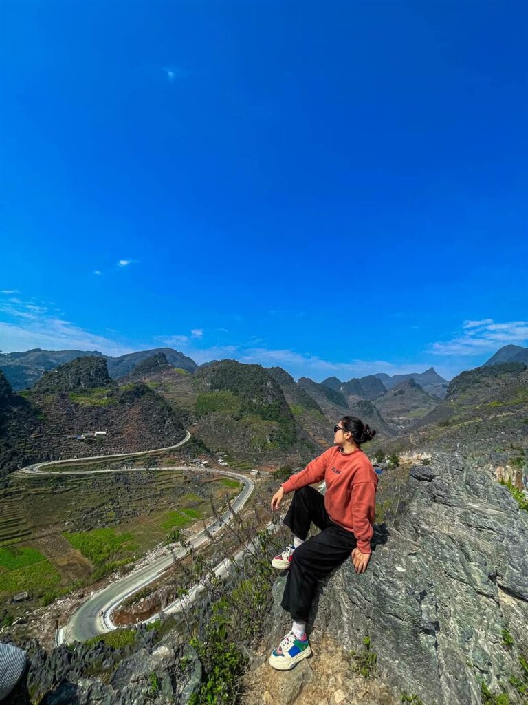
Drone photography has revolutionized how the M-shaped Curve is captured, providing the perfect aerial perspective to showcase its distinctive pattern. However, even without specialized equipment, several natural viewpoints allow travelers to capture stunning images. The most popular photo spot sits approximately 200 meters above the curve on the main road, where a widened shoulder provides safe parking. More adventurous photographers often hike about 15 minutes up a small trail from this point to reach an even higher vantage point offering unobstructed views of both the curve and the valley beyond, creating the perfect composition that has become iconic on travel blogs and social media.
3.2 Comparison with Other Passes (Bac Sum, Ma Pi Leng)
While the M-shaped Curve captivates with its perfect geometric pattern, Ha Giang offers other legendary mountain passes with their own distinct character. Ma Pi Leng Pass, often called Vietnam’s “King of Passes,” dwarfs the M-shaped Curve in terms of scale and drama. At 20 kilometers long with sheer drops of nearly 800 meters to the Nho Que River below, Ma Pi Leng delivers heart-stopping grandeur rather than geometric precision. The experience there centers on vast panoramic views and a sense of exposure, while the M-shaped Curve offers a more intimate, perfectly framed composition.
Bac Sum Pass, located closer to Ha Giang City, features its own smaller M-formation that some travelers mistakenly identify as the famous curve. This section offers gentler gradients and feels less remote, making it more accessible but also less dramatic than the main M-shaped Curve. What distinguishes the true M-shaped Curve from these other passes is its perfect balance of accessibility and adventure. Unlike Ma Pi Leng’s sometimes intimidating scale, the M-shaped Curve feels conquerable and photogenic without requiring extreme driving skills. This perfect middle ground impressive enough to inspire awe while remaining approachable explains why it has become the most photographed road section on the entire loop.

4. How to Experience the M-Shaped Curve
Experiencing the M-shaped Curve goes beyond simply driving through it it’s about immersing yourself in one of Vietnam’s most dramatic landscapes. Most travelers encounter the curve while completing the larger Ha Giang Loop, typically on a motorcycle or with an “easy rider” guide. The curve itself takes only minutes to navigate, but most visitors spend 30-60 minutes here, stopping at viewpoints to photograph the spectacular scenery. The experience changes dramatically with weather and time of day, with early morning fog often creating mystical scenes as sunlight gradually reveals the winding road below.
4.1 Motorbiking/Driving the Curve: Tips and Safety
Navigating the M-shaped Curve requires caution, especially for less experienced riders. The sharp switchbacks demand slow speeds (under 20 km/h) and careful braking before entering each turn. Use your horn approaching blind corners, a common practice throughout Ha Giang to alert oncoming traffic. Keep to the right side, particularly when large trucks or buses approach from the opposite direction, as they often need extra space to navigate the tight turns. During rainy seasons (May-September), be extra vigilant for loose gravel or small rockfalls that can make the surface slippery.
For those concerned about driving skills, Phieu Travel offers guided options with experienced local riders who know every curve intimately. If self-driving, ensure your motorcycle is in good condition with properly functioning brakes and tires with adequate tread. Wearing proper protective gear is essential a quality helmet at minimum, ideally accompanied by gloves and a jacket for additional protection. For photography stops, use designated pull-off areas rather than stopping in the middle of curves, as traffic can appear suddenly around corners. Remember that while the road has guardrails in some sections, many stretches have no protection from steep drops, making careful driving crucial for safety.
4.2 Best Time of Day and Season for Views
The M-shaped Curve transforms dramatically depending on when you visit, with each time offering unique photographic opportunities. Early morning (5:30-7:30 AM) typically provides the most atmospheric conditions, as overnight valley fog creates a mystical setting with the curves emerging from clouds. Mid-morning (8:00-10:00 AM) brings clearer conditions with softer light still ideal for photography. By midday, harsh overhead sun can flatten the visual impact, though the scenery remains impressive. Late afternoon light (3:30-5:30 PM) casts long shadows that accentuate the curve’s distinctive shape once again.
Seasonally, October through April offers the most reliable weather conditions for experiencing the M-shaped Curve at its best. During these months, clear skies predominate with less rainfall, making the roads safer and views more consistent. November through February brings the clearest air quality, allowing for the most dramatic long-distance views across the valleys. Avoid the rainy season (May-September) if possible, as frequent downpours can create dangerous driving conditions and limit visibility. If traveling during summer months, plan to arrive at the curve early in the day, as afternoon thunderstorms are common and can develop quickly in the mountains.
4.3 Nearby Food, Rest, and Viewpoints
Several small family-run cafés have emerged near the main viewpoint overlooking the M-shaped Curve, offering simple refreshments like Vietnamese coffee, instant noodles, and basic snacks. These modest establishments typically operate from bamboo huts with rooftop terraces providing excellent views. About 500 meters past the curve, a larger roadside restaurant serves local mountain specialties including thắng cố (traditional H’mong horsemeat stew) and free-range black chicken dishes, providing an authentic taste of Ha Giang’s highland cuisine after navigating the winding road.
Beyond the main viewing area, several less-visited perspectives offer unique angles on the M-shaped Curve. Approximately 1 kilometer before reaching the main viewpoint (when coming from Meo Vac), a small dirt path leads to an elevated ridge offering a dramatic side view of the entire formation. For more adventurous travelers, a challenging 45-minute hike from the main viewpoint climbs to a rocky outcrop that provides a breathtaking aerial perspective similar to drone footage. If you need a longer rest, the nearby village of Mau Due (15 minutes further along the road) offers several basic homestays where you can experience traditional H’mong hospitality while breaking your journey at this scenic halfway point of the Ha Giang Loop.
5. The M-Shaped Curve in Itineraries
The M-shaped Curve typically features as a highlight on day two or three of most Ha Giang Loop itineraries. Tour operators like Phieu Travel strategically time visits to coincide with optimal lighting conditions, often arriving in early morning when mist creates dramatic effects. Whether you’re completing a quick 2-day express tour or a leisurely 4-day exploration, the curve forms a natural stopping point on the journey between Dong Van and Meo Vac districts. Most travelers spend 30-60 minutes here, though photography enthusiasts often linger longer to capture changing light conditions.
5.1 Suggested Stops and Photo Spots
The primary viewpoint for capturing the M-shaped Curve sits approximately 200 meters above the actual road, at a widened section where several vehicles can safely park. This spot offers the classic overhead perspective that showcases the perfect “M” formation against the backdrop of distant mountains. For more creative compositions, walk about 50 meters further along the main road to find a second viewing angle that incorporates traditional Hmong farmhouses in the foreground, adding cultural context to your landscape shots. Early morning photographers should arrive before sunrise and position themselves facing east to capture dramatic backlighting as the sun crests the mountain ridge.
Several lesser-known vantage points reward travelers willing to explore beyond the main viewpoint. A small trail leading uphill from the parking area reaches a higher perspective after about 15 minutes of moderate hiking. From this elevated position, wider panoramic shots become possible, capturing both the M-shaped Curve and the surrounding valley system. For those interested in including themselves in photos, a flat rock outcropping about 100 meters down from the main viewpoint has become popular for perspective shots that create the illusion of sitting directly above the winding road. Phieu Travel guides can help locate these special photo spots while ensuring safety near the steep terrain.
5.2 Sample 1-day, 3-day, and 4-day Loop Segments
Whether you’re on a short 2-day loop or a longer 4-day journey, the M-shaped Curve naturally fits into most itineraries. Here’s how travelers usually plan their visits and which photo spots are worth a stop.
1-Day Express Route (Not Recommended but Possible):
For extremely time-constrained travelers, an express one-day itinerary from Ha Giang City can reach the M-shaped Curve, though Phieu Travel generally discourages this rushed approach. Departing Ha Giang by 5:00 AM, follow QL4C through Quan Ba and Yen Minh, reaching Dong Van by mid-morning. Continue to Meo Vac for lunch, then west along Provincial Road 182 to reach the M-shaped Curve by early afternoon. This allows about 30 minutes at the curve before the long return journey to Ha Giang, arriving after dark around 8:00 PM. This compressed schedule means limited stops and considerable riding fatigue.

3-Day Classic Itinerary (Most Popular):
A three-day itinerary offers the ideal balance between seeing major highlights and enjoying a comfortable pace. Day one typically covers Ha Giang to Yen Minh or Dong Van, day two explores the Dong Van Karst Plateau including the Hmong King’s Palace and Lung Cu Flag Tower. By late afternoon of day two, most travelers reach Meo Vac for overnight stays in local homestays. On morning of day three, depart Meo Vac early (around 7:00 AM) to reach the M-shaped Curve with beautiful morning light, spending 1-2 hours exploring different viewpoints before continuing to Du Gia for lunch and hot springs, then returning to Ha Giang by evening. This timing ensures you experience the curve with optimal lighting and minimal crowds.

3 Days 2 Nights Ha Giang Loop tour package from Phieu Travel
4-Day Comprehensive Experience:
For those seeking deeper immersion, Phieu Travel’s four-day itinerary allows dedicated time at the M-shaped Curve. Days one and two follow similar routes to the three-day option, reaching Meo Vac on day two. Day three begins with an early morning photography session at the M-shaped Curve (arriving by 6:30 AM), followed by a guided hike to secondary viewpoints and a leisurely breakfast at a local café overlooking the valley. After thoroughly experiencing the curve, the journey continues to Du Gia where you’ll spend the night in a traditional stilt house. Day four includes morning exploration of Du Gia’s waterfall before returning to Ha Giang. This relaxed timeline allows flexibility for weather delays and spontaneous stops at smaller villages along the route.

6. Essential Travel FAQs about the M-Shaped Curve
Travelers consistently ask certain questions when planning their visit to the M-shaped Curve. This section addresses the most common inquiries to help you prepare for an unforgettable experience on this iconic section of the Ha Giang Loop. From practical concerns about road conditions to photography tips and cultural insights, we’ve compiled essential information based on years of guiding visitors through this remarkable landscape. Phieu Travel’s local expertise ensures you’ll have accurate, up-to-date answers to make the most of your time at this breathtaking destination.
6.1 What is the M-shaped Curve in Ha Giang Loop?
The M-shaped Curve is a distinctive section of road in Ha Giang province that forms a perfect letter “M” when viewed from above. Located between Meo Vac and Mau Due districts, this engineering marvel consists of a series of tight switchbacks carved into the mountainside to navigate steep terrain. The road segment spans approximately 800 meters and negotiates an elevation change of about 100 meters through its zigzagging pattern. What makes it remarkable is the perfect symmetry of its curves, creating one of Vietnam’s most photographed road sections and a highlight of the Ha Giang Loop motorcycle route.
Unlike many mountain roads that follow more organic, flowing patterns, the M-shaped Curve features unusually sharp, angular turns that create its distinctive geometric shape. This unusual design resulted from the need to create a manageable gradient for vehicles in extremely steep terrain while working with limited construction technology in the 1960s. Today, it stands as both a practical transportation link for local communities and an iconic symbol of the region’s dramatic landscape that draws thousands of photographers and adventure travelers each year.
6.2 Where exactly is the M-shaped Curve located?
The primary M-shaped Curve that most travelers seek is located on Provincial Road 182, approximately 20 kilometers west of Meo Vac town when heading toward Mau Due district. Its precise coordinates are 23°11’22.5″N 105°24’07.1″E, placing it roughly 170 kilometers from Ha Giang City when following the traditional clockwise loop route. This location sits within the Dong Van Karst Plateau Geopark, a UNESCO-recognized area known for its dramatic limestone formations. The curve appears between the small villages of Pai Lung and Mau Due, in a relatively remote section of the route.
Some confusion exists because a second, less dramatic M-formation appears at Bac Sum Pass (coordinates 23°04’42.2″N 104°58’43.7″E), approximately 45 kilometers from Ha Giang City on the road toward Quan Ba district. While this formation also creates a rough M-shape when viewed from certain angles, it lacks the perfect symmetry and dramatic setting of the main curve between Meo Vac and Mau Due. Travelers doing the complete Ha Giang Loop will encounter both formations, with the more famous and photogenic one typically appearing on day two or three of a standard itinerary.
6.3 Is it safe for beginners to drive or ride the M-shaped Curve?
The M-shaped Curve presents moderate challenges for beginning motorcyclists but remains manageable with proper caution. The road features well-maintained asphalt, clear markings, and guardrails at the most exposed sections. The main difficulties come from the tight switchbacks requiring careful braking and throttle control through the turns. Beginners should approach at very slow speeds (10-15 km/h), use engine braking rather than hard braking within turns, and be especially vigilant for oncoming traffic. Phieu Travel recommends that absolute beginners with no previous motorcycle experience consider hiring a local driver instead of self-riding this section.
Weather significantly impacts safety conditions on the curve. During dry season (October-April), the road surface provides good traction and visibility tends to be clear. However, during rainy months (May-September), water can pool on the road surface and minor rockfalls occasionally occur. If you encounter rain, consider waiting it out at a nearby café rather than attempting the curve in poor conditions. For those concerned about their riding abilities, Phieu Travel offers “easy rider” services where experienced local drivers transport you safely on their motorcycles, allowing you to enjoy the scenery without the stress of navigating challenging sections yourself.
6.4 Can I stop for photos at the M-shaped Curve?
Yes, several designated viewpoints exist specifically for photographing the M-shaped Curve. The primary viewing area includes a widened road shoulder approximately 200 meters above the actual curve, with space for 5-6 vehicles to safely park. This natural balcony offers the classic overhead perspective that showcases the perfect “M” formation. When stopping here, ensure your vehicle is completely off the main roadway and be mindful of other travelers who may also want to use the limited parking space, especially during peak morning hours when the viewpoint becomes busiest.
Beyond the main viewpoint, several smaller pull-offs exist along the road both above and below the curve. When using these secondary stopping points, exercise extreme caution as some lack guardrails and proper barriers. Never step backward without looking first, as edges can be deceptive and drops are substantial. For the most dramatic photos, consider hiking to the elevated viewpoint approximately 15 minutes uphill from the main parking area. This short but steep trail leads to a rocky outcrop offering an unobstructed aerial view of the entire formation. Phieu Travel guides can direct you to the trail entrance, which is easily missed without local knowledge.
6.5 What is the best time of year or day to visit the M-shaped Curve?
October through early December offers the ideal combination of clear weather, comfortable temperatures, and special atmospheric conditions at the M-shaped Curve. During these months, morning mist frequently fills the valleys while skies remain clear above, creating the dramatic setting most photographers seek. January and February provide the clearest long-distance visibility but can be quite cold (sometimes near freezing) in early mornings. March through April brings warmer temperatures and occasional blooming wildflowers on surrounding slopes, adding color to the landscape. The summer rainy season (May-September) delivers lush green scenery but comes with increased risk of rain, fog, and road hazards.
Regarding time of day, early morning from 5:30-7:30 AM provides the most atmospheric conditions. Dawn light combines with overnight valley fog to create mystical scenes as the curves emerge from clouds. By 8:00-10:00 AM, fog typically burns off but lighting remains soft and ideal for photography. Midday (11:00 AM-2:00 PM) brings harsh overhead sun that flattens the visual impact. Late afternoon (3:30-5:30 PM) offers another excellent window as the low-angled light creates dramatic shadows that accentuate the curve’s distinctive shape. Phieu Travel typically schedules visits to coincide with these optimal morning or late afternoon periods, adjusting itineraries to ensure travelers experience the curve in its most photogenic conditions.
6.6 How does the M-shaped Curve compare to other famous passes in Ha Giang?
While the M-shaped Curve captivates with its perfect geometric pattern, it differs significantly from Ha Giang’s other famous mountain passes. Ma Pi Leng Pass, often considered Vietnam’s most spectacular road section, offers far more dramatic scale and exposure. Its 20-kilometer stretch features sheer cliffs dropping 800 meters to the Nho Que River, creating an overwhelming sense of grandeur. By comparison, the M-shaped Curve occupies a more contained area with moderate elevation changes, focusing on the beauty of its precise pattern rather than raw dramatic scale. Most travelers find Ma Pi Leng more awe-inspiring but the M-shaped Curve more visually satisfying and photogenic.
Bac Sum Pass, with its own smaller M-formation, provides a gentler introduction to Ha Giang’s mountain roads. Located closer to Ha Giang City, it features wider roads, more gradual curves, and generally feels less remote than either Ma Pi Leng or the main M-shaped Curve. Tham Ma Pass between Quan Ba and Yen Minh offers excellent forest scenery but lacks the distinctive geometric patterns that make the M-shaped Curve so recognizable. What distinguishes the true M-shaped Curve from these other passes is its perfect balance of accessibility and photogenic quality. While Ma Pi Leng might inspire more awe, the M-shaped Curve consistently produces the most satisfying photographs and social media-worthy moments, explaining its outsized popularity among travelers documenting their Ha Giang adventures.

The M-shaped Curve represents everything that makes the Ha Giang Loop an extraordinary adventure dramatic landscapes, engineering ingenuity, and the thrill of discovery in Vietnam’s remote northern frontier. As you navigate its perfectly symmetrical switchbacks, you’ll understand why this iconic stretch of road has captured the imagination of travelers worldwide. Whether photographed in morning mist or afternoon light, its distinctive pattern creates unforgettable images that embody the spirit of exploration.
While conquering the curve takes just minutes, the memories and photographs will last a lifetime. Plan your visit carefully to experience optimal lighting conditions, and consider spending extra time exploring the various viewpoints that showcase this marvel from different perspectives. Remember that beyond its photogenic appeal, the M-shaped Curve connects real communities and represents the remarkable effort to bring accessibility to Ha Giang’s isolated mountain villages.
For those ready to experience the perfect blend of adventure, culture and breathtaking scenery along the M-shaped Curve Ha Giang, Phieu Travel offers expertly guided tours with local knowledge that enhances every aspect of your journey. Our experienced guides know exactly when and where to stop for the best views and can share fascinating insights about the region’s history and culture. Visit Phieutravel.com to book your Ha Giang adventure and discover why this remote corner of Vietnam continues to captivate the hearts of travelers seeking authentic experiences beyond the ordinary.
Read more:
- Beyond the Beaten Path: Discovering Ha Giang Province in Northeast Vietnam
- Ha Giang weather in October: climate, best time to visit & tips
- La Chi People Vietnam – History, Culture, Traditions & Villages in Ha Giang
You Might Also Like
Ha Giang Weather in September: Complete Guide for Travelers
Exploring the magnificent Ha Giang Loop in September offers travelers a perfect balance of favorable[...]
3 Comments
Quan Ba Twin Mountains: Ha Giang’s Iconic Fairy Hills and Complete Travel Guide
The mystical Quan Ba Twin Mountains rise from the emerald valleys of Ha Giang like[...]
Vuong family mansion: the architectural marvel and cultural legacy of Ha Giang
Deep in Vietnam’s northern highlands, where mist-shrouded mountains meet terraced rice fields, stands a testament[...]
Ha Giang Loop Safety Tips: How to Ride Securely in Vietnam’s Northern Mountains
The Ha Giang Loop, with its winding mountain roads and breathtaking landscapes, offers one of[...]
The Ultimate Guide to the M-Shaped Curve on Ha Giang Loop
Vietnam’s remote northern province of Ha Giang hides a natural wonder that has captivated adventurous[...]
Most Beautiful Places to Visit in Vietnam: Essential Destinations and Insider Tips
Vietnam captivates travelers with its stunning landscapes, rich cultural heritage, and warm hospitality. From mist-shrouded[...]
3 Comments
Beyond the Beaten Path: Discovering Ha Giang Province in Northeast Vietnam
Ha Giang Province in Northeast Vietnam stands as one of the country’s last frontiers for[...]
6 Comments
Rainy season in Ha Giang: what to expect, when to go, and travel tips
Vietnam’s northern frontier reveals a different face during the rainy season, transforming Ha Giang’s limestone[...]