
The mystical Quan Ba Twin Mountains rise from the emerald valleys of Ha Giang like twin sentinels guarding the gateway to Vietnam’s northern frontier. These perfectly rounded limestone formations have captivated travelers for generations, not only for their striking symmetry but also for the poignant legend that breathes life into the landscape. As the first major landmark on the legendary Ha Giang Loop, the Twin Mountains offer visitors a dramatic introduction to the geological wonders and cultural richness of Vietnam’s northernmost province. This comprehensive guide explores everything you need to know about this iconic destination, from practical travel tips to the ancient folklore that makes Quan Ba Twin Mountains one of Vietnam’s most photographed natural attractions.

1. Overview of Quan Ba Twin Mountains
Nestled in Quan Ba District of Ha Giang Province, the Twin Mountains (also known as Co Tien or Fairy Mountains) stand as the defining landmark of the region. These two perfectly rounded hills rise prominently from the valley floor, creating a distinctive silhouette against the backdrop of jagged limestone peaks. Their unique, breast-like shape has earned them the local nickname “Nui Doi” (Twin Mountains) or more poetically, “Fairy Bosom Mountains.”
The Twin Mountains are located approximately 46 kilometers north of Ha Giang City, marking the entrance to the UNESCO-recognized Dong Van Karst Plateau Geopark. This geographic position places them at a crucial junction on the Ha Giang Loop, making them both a symbolic and literal gateway to the province’s most spectacular landscapes. Many travelers consider this their first major destination after leaving Ha Giang City.
What makes these mountains truly special is not just their unusual formation but also their cultural significance. For the Hmong, Dao, and other ethnic communities who have lived in these valleys for centuries, the mountains represent more than a geological oddity – they embody ancient legends and spiritual beliefs that continue to influence local culture. The harmonious balance between natural wonder and cultural heritage makes the Quan Ba Twin Mountains an essential stop for anyone seeking to understand the soul of Ha Giang.

Vi Xuyen District, Ha Giang: Complete guide to Vietnam’s historic frontier
2. How to Get There and Best Visiting Tips
Visiting Quan Ba Twin Mountains is as much about the journey as the destination itself. Located at the gateway of the Dong Van Karst Plateau, reaching the site requires navigating winding mountain roads that already showcase Ha Giang’s dramatic scenery. Before setting out, travelers should understand the different transport options, travel times, and seasonal considerations to make the most of their trip.
2.1 Reaching Quan Ba Twin Mountains
The journey to Quan Ba Twin Mountains begins in Ha Giang City, which serves as the starting point for most explorations of the region. From Hanoi, you’ll first need to reach Ha Giang by sleeper bus (6-7 hours) or private vehicle (approximately 300 kilometers). Once in Ha Giang City, the most popular way to reach Quan Ba is by motorbike along National Highway 4C, also known as the Happiness Road.
The ride from Ha Giang to Quan Ba takes about 1.5 to 2 hours, covering roughly 46 kilometers of winding mountain roads. The route includes crossing the famous Bac Sum Pass, which offers the first taste of Ha Giang’s dramatic landscapes. If you’re not comfortable riding a motorbike, alternatives include hiring a car with driver or joining an organized tour through companies like Phieu Travel, which provide experienced drivers familiar with the mountain terrain.
For those seeking public transportation, local buses run between Ha Giang City and Quan Ba district, though schedules can be limited and the experience less flexible than private transport. The best approach is to check current schedules at Ha Giang’s main bus station or consult with your accommodation for the latest information.
2.1 Best Visiting Tips
Timing your visit properly can significantly enhance your experience. Early morning (6-8 AM) often provides the clearest views before the afternoon mist rolls in. If possible, try to arrive at Heaven’s Gate viewpoint just after sunrise when soft light bathes the valley and Twin Mountains below.
Weather considerations are crucial when planning your trip. The ideal visiting season runs from September to November and March to May, when rainfall is minimal and skies tend to be clearer. During these months, temperatures range from comfortable to cool, making exploration more pleasant. Winter months (December–February) can be stunningly clear but quite cold, requiring warm clothing, especially for motorcycle travelers.
When visiting, don’t rush the experience. Plan to spend at least 1-2 hours at Heaven’s Gate viewpoint and surrounding areas. This allows time to not only photograph the Twin Mountains but also explore nearby facilities like the small market, where local Hmong vendors sell traditional crafts and refreshments. Consider bringing binoculars to appreciate distant details and a good camera with a wide-angle lens to capture the expansive landscape.

3. The Legend of the Fairy Mountains (Co Tien Legend)
The Quan Ba Twin Mountains are inseparable from their enchanting origin story, which has been passed down through generations of local ethnic minorities. According to the most widespread version of the legend, the mountains were formed from the breasts of a heartbroken fairy who fell in love with a human.
Long ago, in the remote valleys of what is now Ha Giang, a beautiful fairy descended from heaven and fell deeply in love with a talented flute player from the Hmong community. Their forbidden love blossomed in secret, but eventually, the King of Heaven discovered their relationship. Furious about this violation of heavenly law, he forcibly separated the lovers, dragging the fairy back to heaven and leaving her earthly lover behind.
Overcome with grief and longing, the fairy wept endlessly for her lost love. Her tears flowed down to earth, nourishing the valley below. As a final act of devotion, she cut off her breasts and cast them down to the mortal world, believing they would nurture the land and people her lover cherished. Where they fell, two perfectly rounded hills formed – the Twin Mountains we see today.
Local variations of the story exist, with some versions claiming the mountains represent the nurturing spirit of Mother Earth or that they were created as landmarks to help a pair of lost lovers find each other. Regardless of the specific telling, all versions share common themes of love, sacrifice, and the enduring connection between heaven and earth. For the ethnic communities of Quan Ba, these mountains are not merely geological formations but sacred reminders of love’s power and sacrifice’s nobility.
This poignant legend adds an emotional dimension to visitors’ experience, transforming a stunning landscape into a place of deep cultural resonance. When you gaze upon the Twin Mountains, you’re not just admiring a natural wonder but connecting with centuries of local folklore and belief.

Ha Giang weather in October: climate, best time to visit & tips
4. Geography, Geology, and Scenic Highlights
Beyond its cultural legends, the Twin Mountains also fascinate geologists and landscape photographers alike. Their rounded shape contrasts sharply with the jagged limestone peaks of Ha Giang, making them both a geological curiosity and a scenic icon. Understanding the natural forces that shaped them helps visitors appreciate why the Quan Ba Twin Mountains are such a unique landmark within the UNESCO-recognized geopark.
The Quan Ba Twin Mountains are situated within the vast limestone karst landscape of northern Vietnam, specifically within the Dong Van Karst Plateau Geopark – Vietnam’s first UNESCO-recognized Global Geopark. This plateau represents one of Southeast Asia’s most spectacular karst formations, characterized by sharp limestone peaks, deep valleys, and a complex underground cave system.
Geologically speaking, the Twin Mountains are dolomite formations that have been shaped by millions of years of erosion and tectonic activity. Unlike the jagged peaks surrounding them, these formations have been weathered into smooth, rounded shapes that stand out dramatically from the landscape. Scientists believe their unusual form results from a combination of the region’s unique rock composition and centuries of natural weathering processes.
The mountains sit at an elevation of approximately 1,000-1,200 meters above sea level, within a valley that creates a perfect frame for their distinctive silhouette. This location, combined with the surrounding karst topography, creates a microclimate that often features morning mist and dramatic cloud formations, further enhancing the mountains’ mystical appearance.
4.1 Most Scenic Viewpoints & Photography Tips
The premier vantage point for admiring the Twin Mountains is undoubtedly Quan Ba Heaven’s Gate (Cổng Trời Quản Bạ), situated along Highway 4C at an elevation of about 1,500 meters. This natural pass offers an unobstructed panoramic view of the entire valley below, with the Twin Mountains as the focal point. The viewpoint features a developed observation deck with stone steps and railings, making it accessible for most visitors.
For photographers seeking the perfect shot, the Heaven’s Gate viewpoint offers various compositions. Wide-angle lenses (16-35mm) work best to capture the mountains within their dramatic landscape context. Early morning or late afternoon provides optimal lighting, with side lighting that highlights the mountains’ contours. On misty mornings, a telephoto lens can capture the mountains emerging from the fog – a particularly ethereal scene.
Beyond the main viewpoint, adventurous travelers can find alternative perspectives by following small paths that lead to less crowded vantage points. The road leading down from Heaven’s Gate toward Tam Son town offers several pullover spots with different angles of the Twin Mountains. For those willing to explore further, hiring a local guide can lead to hidden viewpoints known mainly to residents.
4.2 Best Seasons and Weather Conditions
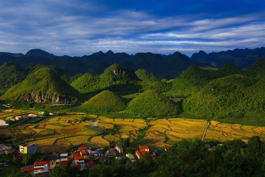
The visual appearance of the Quan Ba Twin Mountains transforms dramatically with the seasons, offering visitors different experiences throughout the year. October to November marks the harvest season, when the valley floor turns golden with ripening rice, creating a stunning contrast with the green mountains and blue sky. This period also coincides with the blooming of buckwheat flowers, which paint portions of the landscape in soft pink and purple hues.
February to April represents the spring season, when fresh growth brings vibrant green to the terraced fields surrounding the mountains. During this period, fruit trees blossom throughout the valley, adding splashes of white and pink to the scenery. Though beautiful, spring can bring increased rainfall, occasionally obscuring the mountains with mist and clouds.
Winter months (December-January) offer the clearest air and sharpest visibility, though temperatures can drop significantly, especially in the early morning. Summer (May-September) brings lush vegetation but also marks the rainy season, with increased chance of heavy fog and downpours that can limit visibility.
Weather conditions can change rapidly in this mountainous region. Even during optimal seasons, it’s advisable to build flexibility into your itinerary, allowing for a second visit if clouds obscure your first viewing opportunity. Local weather patterns typically feature clearer mornings and cloudier afternoons, making early visits advisable regardless of season.

5. Local Experiences, Culture, and Nearby Attractions
A visit to the Twin Mountains isn’t complete without exploring the cultural and community life that surrounds them. The valleys of Quan Ba are home to diverse ethnic groups whose traditions enrich the landscape with color and authenticity. From bustling local markets to ancient weaving villages, travelers can complement their scenic journey with meaningful cultural encounters.
5.1 Interaction with Ethnic Communities
The area surrounding Quan Ba Twin Mountains is home to diverse ethnic minority groups, primarily Hmong, Dao, and Tay peoples, each with distinct cultural traditions. These communities maintain traditional lifestyles that have adapted to the challenging mountain environment over centuries. Visitors have several opportunities to engage respectfully with local culture during their visit to Quan Ba.
Sunday markets represent one of the most authentic cultural experiences in the region. The Tam Son market, located just a few kilometers from the Twin Mountains viewpoint, draws ethnic minority people from surrounding villages. Here, you can observe traditional clothing, sample local foods, and perhaps purchase handcrafted textiles or silver jewelry. The market operates weekly, with the busiest hours between 7-10 AM.
For deeper cultural immersion, several homestays in the Quan Ba area offer accommodation in traditional houses. These experiences typically include home-cooked meals featuring local specialties like thang co (a hearty meat stew), smoked meats, and corn wine. Staying with local families provides insight into daily life and sometimes opportunities to participate in activities like weaving, farming, or food preparation.
When interacting with ethnic communities, remember that many older residents may not speak Vietnamese or English. Respectful photography practices are essential – always ask permission before taking photos of people, particularly children. Consider hiring a local guide who can translate and provide cultural context, enhancing both your experience and your contribution to the local economy.
5.2 Suggested Short Itinerary from Ha Giang
A well-planned itinerary allows you to experience Quan Ba Twin Mountains as part of a broader exploration of Ha Giang’s highlights. Here’s a suggested two-day route that incorporates the Twin Mountains and complementary attractions:
Day 1: Ha Giang to Dong Van
- Early morning departure from Ha Giang City.
- Bac Sum Pass and first mountain views.
- Quan Ba Heaven’s Gate and Twin Mountains (2-3 hours).
- Lunch in Tam Son town, possibly visiting the local market.
- Continue to Yen Minh Pine Forest for afternoon exploration.
- Overnight in historic Dong Van Ancient Town.
Day 2: Dong Van to Ha Giang
- Morning visit to Lung Cu Flag Tower (Vietnam’s northernmost point).
- Explore Ma Pi Leng Pass and view Nho Que River.
- Lunch in Meo Vac town.
- Return journey to Ha Giang via alternative route.
This compact itinerary can be expanded to 3-4 days Hagiang Loop tours for a more leisurely pace. For those with limited time, Phieu Travel offers single-day excursions from Ha Giang that focus primarily on Quan Ba and nearby attractions, returning to the city by evening.
Beyond the Twin Mountains, nearby points of interest include Lung Khuy Cave with its impressive stalactite formations (about 15km from Quan Ba), the Hmong King’s Palace in Sa Phin commune, and the picturesque Lung Tam linen weaving village. Each of these destinations adds cultural and natural dimensions to your understanding of the region, creating a more comprehensive Ha Giang experience.

6. Frequently Asked Questions about Quan Ba Twin Mountains
Visiting Quan Ba Twin Mountains often raises practical questions for first-time travelers. To help you plan your trip with confidence, here are answers to the most common queries about location, travel routes, best seasons, and cultural significance.
6.1 Where are the Quan Ba Twin Mountains located?
The Quan Ba Twin Mountains are located in Quan Ba District of Ha Giang Province, northern Vietnam. They sit approximately 46 kilometers north of Ha Giang City along National Highway 4C (Happiness Road). Specifically, they’re visible from Quan Ba Heaven’s Gate pass, which marks the entrance to the UNESCO-recognized Dong Van Karst Plateau Geopark. The mountains themselves are situated in the valley below the pass, near Tam Son town, the district capital of Quan Ba.
6.2 What is the legend of the Quan Ba Twin Mountains?
According to local folklore, the Twin Mountains were formed from the breasts of a fairy who fell in love with a human. When their forbidden relationship was discovered, the heavenly authorities separated the lovers. Heartbroken, the fairy cut off her breasts and cast them down to earth as a final gift to nurture the land her lover inhabited. Where they fell, the Twin Mountains formed. This poignant story explains both their distinctive shape and their local name, “Fairy Mountains” (Núi Cô Tiên).
6.3 How do I get to Quan Ba Twin Mountains or Quan Ba Heaven Gate?
From Ha Giang City, the most common approach is by motorbike or car along National Highway 4C. The journey takes approximately 1.5-2 hours and covers 46 kilometers of mountain roads, including the scenic Bac Sum Pass. Motorbike rental services are widely available in Ha Giang, with prices ranging from 150,000 to 300,000 VND per day. Alternatively, you can hire a car with driver (around 1,000,000-1,500,000 VND per day) or join organized tours. Public buses also run from Ha Giang to Tam Son town, though with limited schedules.
6.4 What is the best time to visit Quan Ba Twin Mountains?
The optimal visiting periods are September to November and March to May, when weather conditions typically feature clear skies and moderate temperatures. October and November offer golden rice terraces as a beautiful foreground to the mountains. For photography, early morning (6-8 AM) provides the best lighting and clearest views before afternoon clouds gather. Weekdays generally see fewer tourists than weekends. If visiting during December to February, prepare for cold temperatures, especially in the early morning, though visibility is often excellent during this season.
6.5 What can you see from Quan Ba Heaven Gate?
From Quan Ba Heaven Gate viewpoint, visitors enjoy a spectacular panoramic vista that includes the Twin Mountains as the centerpiece, surrounded by terraced rice fields, traditional villages, and the dramatic karst landscape of the Dong Van Plateau. On clear days, the view extends for kilometers across the valley, with layers of mountains fading into the distance. The observation area includes informational displays about the geology and cultural significance of the region. Small vendors sell local products and refreshments, and there’s a coffee shop where you can enjoy the view at a more leisurely pace.
6.6 Why are the Quan Ba Twin Mountains famous?
The Quan Ba Twin Mountains have gained fame for several reasons: their perfectly symmetrical, breast-like shape that stands out dramatically from the surrounding jagged karst landscape; their association with the romantic fairy legend that has become emblematic of the region; their status as the first major scenic highlight on the popular Ha Giang Loop; and their photogenic quality that makes them one of Vietnam’s most recognizable natural landmarks. Additionally, as part of the UNESCO-recognized Dong Van Karst Plateau Geopark, they represent the geological and cultural heritage that has put Ha Giang on the international tourism map.
The Quan Ba Twin Mountains stand as both natural wonder and cultural treasure, embodying the unique spirit of Ha Giang Province. Their distinctive silhouette, visible from Heaven’s Gate pass, creates an unforgettable first impression for travelers embarking on the legendary Ha Giang Loop. Beyond their striking appearance, these mountains carry the weight of ancient legends, connecting visitors to the rich folklore and traditions of northern Vietnam’s ethnic communities.
Whether you’re drawn by the poignant fairy tale, the spectacular karst landscape, or the photographic opportunities, Quan Ba Twin Mountains reward visitors with an experience that transcends mere sightseeing. The changing seasons transform their appearance, from the golden hues of autumn harvest to the lush greens of spring, ensuring that no two visits are quite the same.
For travelers seeking authentic cultural experiences alongside natural beauty, the surrounding villages and markets offer genuine insights into the lives of the Hmong, Dao, and other ethnic groups who have called these mountains home for generations. Their traditions and adaptations to this striking landscape add depth to any visit.
As you plan your journey to Ha Giang, consider partnering with Phieu Travel for expert guidance through this remarkable region. Their local knowledge and responsible tourism practices help ensure that your experience of the Quan Ba Twin Mountains and broader Ha Giang Loop is both memorable and respectful of local communities. Learn more about their customized tours and services at Phieutravel.com, where the magic of Quan Ba Twin Mountains is just the beginning of your northern Vietnam adventure.
Read more:
- Vuong family mansion: the architectural marvel and cultural legacy of Ha Giang
- Ha Giang Loop Safety Tips: How to Ride Securely in Vietnam’s Northern Mountains
- The Ultimate Guide to the M-Shaped Curve on Ha Giang Loop
You Might Also Like
Ha Giang Weather in September: Complete Guide for Travelers
Exploring the magnificent Ha Giang Loop in September offers travelers a perfect balance of favorable[...]
3 Comments
Quan Ba Twin Mountains: Ha Giang’s Iconic Fairy Hills and Complete Travel Guide
The mystical Quan Ba Twin Mountains rise from the emerald valleys of Ha Giang like[...]
Vuong family mansion: the architectural marvel and cultural legacy of Ha Giang
Deep in Vietnam’s northern highlands, where mist-shrouded mountains meet terraced rice fields, stands a testament[...]
Ha Giang Loop Safety Tips: How to Ride Securely in Vietnam’s Northern Mountains
The Ha Giang Loop, with its winding mountain roads and breathtaking landscapes, offers one of[...]
The Ultimate Guide to the M-Shaped Curve on Ha Giang Loop
Vietnam’s remote northern province of Ha Giang hides a natural wonder that has captivated adventurous[...]
Most Beautiful Places to Visit in Vietnam: Essential Destinations and Insider Tips
Vietnam captivates travelers with its stunning landscapes, rich cultural heritage, and warm hospitality. From mist-shrouded[...]
3 Comments
Beyond the Beaten Path: Discovering Ha Giang Province in Northeast Vietnam
Ha Giang Province in Northeast Vietnam stands as one of the country’s last frontiers for[...]
6 Comments
Rainy season in Ha Giang: what to expect, when to go, and travel tips
Vietnam’s northern frontier reveals a different face during the rainy season, transforming Ha Giang’s limestone[...]