
Following the success of the film “Tet in Hell Village,” Sao Ha Village quickly became a sought-after destination for many travelers. Located in the heart of Dong Van Karst Plateau, this village served as the main setting for the popular horror film, leaving a lasting impression with its hauntingly beautiful scenery that blends ancient charm with the poetic landscape characteristic of Northern Vietnam’s mountains. Join Phieu Travel to discover more about this famous village!
1. Introduction to Sao Ha Village
Sao Ha Village is a small Hmong settlement nestled deep within Kho Cho hamlet in Van Chai commune, Dong Van district. “Sao Ha” in the Hmong language means “high valley,” accurately describing the village’s location at approximately 2,000 meters above sea level.
The village is not yet clearly marked on Google Maps. Travelers typically input “Kho Cho” as their destination, then ask locals for further directions. The path to the village is a narrow, rocky trail with many slippery and steep sections, accessible only by manual motorbikes. In some areas, you’ll need to push your bike or even climb by hand through bamboo forests and cat’s-ear rocky slopes.
Situated in the middle of a 500-hectare primeval forest, the village completely lacks electricity, running water, or phone signal. Life here maintains its ancient rhythms. Villagers grow corn, flax, mustard greens, raise goats, and hand-weave textiles for their livelihood. Though previously little-known, Sao Ha suddenly gained attention when it became the filming location for “Tet in Hell Village,” thanks to its pristine beauty and isolation from the outside world.

The Ultimate Ha Giang Loop Guide (2025): Itinerary, Map & Tips
2. Witnessing the Mystical Beauty of Sao Ha Village
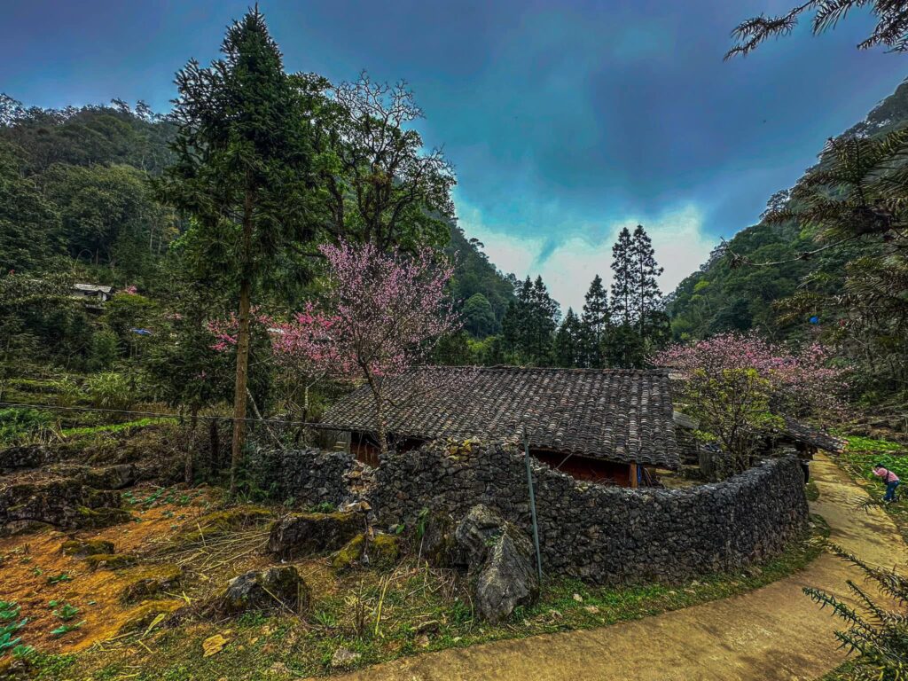
After climbing the steep slope, visitors encounter a shrine to the forest deity. This marks the entrance to the primeval forest with its distinctive scent of flax plants. Within this space lies Sao Ha Village with its 22 earth-walled houses scattered along the trails. The walls are made of thick compressed earth, with yin-yang tiled roofs, surrounded by stone fences approximately 1.5 meters high.

Each season brings a different beauty to the village. Spring bursts with peach blossoms around courtyards. Summer and autumn see clouds drifting lazily along the trails. Winter brings bitter cold with fog enveloping the village all day long. Though it served as the setting for “Tet in Hell Village,” Sao Ha is actually very peaceful, serene, and poetic in reality.

The village is also tied to a special historical milestone. In the late 1950s, after a failed uprising, the tribal leader Vang Van Ly took refuge with his family on this mountaintop. After surrendering, he and his clan settled here permanently. As a result, most Hmong people in Sao Ha still carry the Vang surname to this day.
The Ultimate Guide to Driving the Ha Giang Loop by Car from Hanoi
3. Checklist for Exploring Sao Ha Village
If you’re planning to explore Sao Ha Village, here are three essential things you need to know:
3.1 Best Time to Visit
Spring is the ideal time to explore Sao Ha Village. From February to March, peach and plum blossoms bloom throughout the village, bringing bright pink colors that soften the cold, somber atmosphere of the deep forest.
During autumn and winter, temperatures drop significantly, and fog frequently blankets the area. If traveling between October and December, prepare warm clothing and non-slip shoes to ensure safety when navigating the rocky, steep terrain.

3.2 How to Reach Sao Ha Village
From Yen Minh district center, drive along National Highway 4C through the 17km Happiness Pass, continue 4km past Tham Ma slope, then turn into Van Chai commune. From there, ask locals for directions to Kho Cho hamlet, then travel approximately 2km along the trail to reach the village.
The trail to the village gets increasingly narrow, with loose gravel, steep inclines, and slippery sections. Manual motorbikes are the only vehicles that can access it, but many sections require pushing or climbing by hand. If you’re unfamiliar with the terrain, it’s advisable to go with a local guide for safety. The walking time to the village typically takes about 30-45 minutes.

3.3 Why It’s Called the “Three-Nothings” Village
Sao Ha Village is called the “three-nothings village” because it completely lacks electricity grid, running water, and phone signal. The village lies deep within a primeval forest, totally separated from the outside world, without any modern conveniences.
Villagers sustain themselves by growing corn, weaving textiles, raising livestock, collecting water from streams, and using firewood for cooking. This isolation creates a profound stillness and a unique atmosphere that cannot be found elsewhere.

Sao Ha Village is included in the Ha Giang tour itinerary organized by Phieu Travel. Local guides who know the routes and terrain well, especially the steep slopes and cat’s-ear rocky paths, lead the tours. The tour provides manual motorbikes, protective gear, and water, ensuring you can confidently and safely conquer this special village.
Above is information about Sao Ha Village in Ha Giang. With its complex terrain, harsh climate, and unique living conditions, thorough preparation before visiting this village is essential. If you need a reliable companion for your Ha Giang adventure, don’t hesitate to contact Phieu Travel right away!
Read more:
- Five-Colored Sticky Rice: An Exquisite Art of Highland Cuisine
- Thang Co – The H’Mong People’s 200-Year-Old Exotic Stew
- Top 7 Benefits of the Herbal Bath of Dao People You Must Try in Northern Vietnam
- Hidden Paradises: The Enchanting Waterfalls on the Ha Giang Loop
You Might Also Like
Ha Giang Weather in September: Complete Guide for Travelers
Exploring the magnificent Ha Giang Loop in September offers travelers a perfect balance of favorable[...]
3 Comments
Quan Ba Twin Mountains: Ha Giang’s Iconic Fairy Hills and Complete Travel Guide
The mystical Quan Ba Twin Mountains rise from the emerald valleys of Ha Giang like[...]
Vuong family mansion: the architectural marvel and cultural legacy of Ha Giang
Deep in Vietnam’s northern highlands, where mist-shrouded mountains meet terraced rice fields, stands a testament[...]
Ha Giang Loop Safety Tips: How to Ride Securely in Vietnam’s Northern Mountains
The Ha Giang Loop, with its winding mountain roads and breathtaking landscapes, offers one of[...]
The Ultimate Guide to the M-Shaped Curve on Ha Giang Loop
Vietnam’s remote northern province of Ha Giang hides a natural wonder that has captivated adventurous[...]
Most Beautiful Places to Visit in Vietnam: Essential Destinations and Insider Tips
Vietnam captivates travelers with its stunning landscapes, rich cultural heritage, and warm hospitality. From mist-shrouded[...]
3 Comments
Beyond the Beaten Path: Discovering Ha Giang Province in Northeast Vietnam
Ha Giang Province in Northeast Vietnam stands as one of the country’s last frontiers for[...]
3 Comments
Rainy season in Ha Giang: what to expect, when to go, and travel tips
Vietnam’s northern frontier reveals a different face during the rainy season, transforming Ha Giang’s limestone[...]