

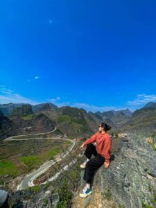
Towering at 2,428 meters above sea level, Tay Con Linh Peak stands as the magnificent “Roof of Northeast Vietnam”—a destination that beckons adventurers seeking both rigorous challenge and profound serenity. Straddling the Vi Xuyen and Hoang Su Phi districts of Ha Giang province, this majestic summit is an essential detour for those looking to elevate their Ha Giang Loop experience beyond the standard driving routes.
The ascent offers trekkers an immersive journey through ancient tea forests, secluded ethnic minority villages, and an untamed wilderness rarely experienced by mainstream tourists. While Fansipan may claim fame as the nation’s highest peak, Tay Con Linh rewards the discerning traveler with authentic cultural encounters, pristine natural environments, and the deep satisfaction of conquering one of Vietnam’s most challenging yet underappreciated summits. For those navigating the Ha Giang Loop, Tay Con Linh represents the ultimate frontier of high-altitude exploration.

1. Overview: Tay Con Linh Vietnam’s Northeastern Roof
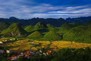
Tay Con Linh Peak is more than just a mountain it’s a complete ecosystem and cultural landscape that represents the wild heart of northeastern Vietnam. Standing proudly at 2,428 meters (7,966 feet), it reigns as the highest summit in the region, offering breathtaking panoramic views across Ha Giang province and beyond. The mountain spans both Vi Xuyen and Hoang Su Phi districts, creating a diverse topography that transitions from lush valleys to misty alpine environments.
Unlike its more famous cousin Fansipan in Lao Cai province, Tay Con Linh remains relatively untouched by commercial tourism infrastructure. This preservation has maintained the mountain’s raw, authentic character, making it especially appealing for adventurers seeking genuine wilderness experiences. Its slopes are home to some of Vietnam’s most ancient Shan Tuyet tea forests, where 300-year-old trees continue to produce highly prized tea leaves.
The mountain holds profound cultural significance for the ethnic minorities who have lived in its shadow for centuries. Home primarily to the La Chi, Dao, Nung, and Hmong peoples, the surrounding villages maintain traditional practices deeply connected to the mountain’s natural rhythms. Their respect for the peak is evident in local folklore, which often portrays Tay Con Linh as a benevolent guardian watching over the region’s inhabitants.

2. Location and Getting There
Tay Con Linh Peak is situated approximately 40 kilometers southwest of Ha Giang City, in Vietnam’s northernmost province. The mountain straddles both Vi Xuyen and Hoang Su Phi districts, with most trekking routes beginning from either Nam Son commune in Vi Xuyen or Ho Thau commune in Hoang Su Phi. This remote location contributes to its pristine condition but also presents logistical challenges for visitors.
Access to the trailheads requires careful planning and typically involves multiple transportation stages. Most travelers first arrive in Ha Giang City, which serves as the gateway to the entire region and the natural starting point for any Tay Con Linh adventure. From Hanoi, Ha Giang can be reached via a 6-7 hour bus journey, with multiple daily departures available from My Dinh or Gia Lam bus stations.
2.1. Main access routes from Ha Giang City
The two primary access routes to Tay Con Linh Peak offer distinctly different experiences, with each having its own advantages depending on your trekking preferences and time constraints.
- Nam Son Route (Eastern Approach): This traditional route begins from Nam Son commune in Vi Xuyen district, approximately 35 kilometers from Ha Giang City. From the commune center, a 4-5 hour trek leads to the base camp area. This path is considered more direct but steeper, with the complete trek to the summit typically taking 2-3 days round trip. The route passes through dense forest and offers fewer village encounters, making it suitable for trekkers seeking wilderness immersion.
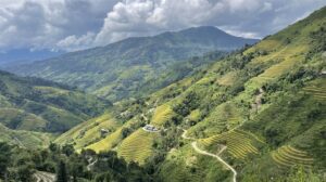
- Ho Thau Route (Western Approach): Beginning from Ho Thau commune in Hoang Su Phi district, this longer route passes through several La Chi and Dao villages and the ancient Shan Tuyet tea forests. The approach takes about 80 kilometers from Ha Giang City to reach the trailhead, but rewards travelers with richer cultural interactions and more diverse landscapes. This route typically requires 3-4 days to complete but offers a more comprehensive experience of the mountain’s cultural and ecological diversity.
2.2. Transport options
Getting to Tay Con Linh’s trailheads requires a combination of transportation methods, each with varying levels of comfort and flexibility.
- Public Transportation: Local buses run from Ha Giang City to district centers near both trailheads, though schedules can be limited and often require connections. From the district centers, motorcycle taxis (xe om) can be arranged to reach the actual starting points. This option works best for budget travelers with flexible schedules and basic Vietnamese language skills.
- Private Car/Jeep Hire: For groups or those with limited time, hiring a private vehicle in Ha Giang City provides the most direct access to either trailhead. Expect to pay 600,000-1,200,000 VND per day depending on the vehicle type and distance. Phieu Travel can arrange reliable drivers familiar with the mountain access points, ensuring you start your trek without unnecessary delays.
- Motorbike Rental: Adventure enthusiasts might prefer renting motorbikes in Ha Giang (150,000-250,000 VND per day) to reach the trailheads independently. This option offers maximum flexibility but requires confident riding skills, as roads to both Nam Son and Ho Thau feature steep sections and occasional rough terrain, especially during rainy seasons.

Ha Giang Motorbike Loop: The Ultimate Tour with Phieu Travel
3. Trekking Tay Con Linh
Trekking to Tay Con Linh Peak presents a genuine adventure that demands proper preparation and respect for the mountain’s challenges. Unlike more developed trekking destinations in Vietnam, the routes here remain largely untouched by tourism infrastructure, preserving their authentic character but also requiring self-sufficiency from trekkers. The mountain offers various route options catering to different experience levels, though none would be classified as easy.
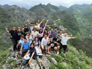
Most trekking expeditions are organized with local guides who know the mountain intimately and can navigate its sometimes unclear paths. These guides, often from La Chi or Dao communities, bring invaluable knowledge about safe routes, water sources, and weather patterns. Their cultural insights also enrich the journey, connecting trekkers to the mountain’s human history.
Overnight accommodations typically involve either camping at designated sites or homestays in villages at lower elevations. Basic facilities exist at established campsites, but trekkers should be prepared for wilderness camping conditions, especially on multi-day routes to the summit. The reward for these efforts comes in the form of pristine environments, star-filled skies, and a profound connection to one of Vietnam’s most magnificent natural landscapes.

3.1. Trekking stages and timelines
Conquering Tay Con Linh typically involves a multi-day commitment, with the journey divided into distinct stages that showcase the mountain’s diverse ecosystems and challenges.
Stage 1: Beginning the Journey (Day 1, 5-6 hours)
The trek begins from either Nam Son or Ho Thau commune, starting through agricultural land before transitioning to forest paths. From Nam Son, the trail climbs steadily through bamboo forests and crosses several small streams. The Ho Thau route offers a gentler start, winding through ancient tea plantations and ethnic minority villages where trekkers can observe traditional activities. This stage typically concludes at a campsite or homestay at approximately 1,200-1,400 meters elevation, where basic amenities and meals prepared by local guides provide welcome comfort after the day’s exertion.
Stage 2: Climbing the Rocky Faces (Day 2, 6-7 hours)
The second day presents increased challenges as the trail steepens significantly and the ecosystem transitions to more alpine characteristics. Rocky outcroppings require occasional scrambling, while the air noticeably thins at higher elevations. Vegetation shifts from dense forest to more scattered growth, offering increasingly dramatic views across Ha Giang’s mountains. Trekkers typically establish camp at around 2,000 meters, either at a plateau area or protected ravine depending on weather conditions. This higher camp offers spectacular sunset views, though temperatures drop considerably after dark.
Stage 3: Summit Push and Descent (Day 3, 8-9 hours)
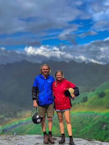
The final ascent begins early, often before dawn to maximize clear viewing conditions at the summit. The trail becomes more technical in sections, with some rocky areas requiring careful footing. After 2-3 hours of climbing, trekkers reach the 2,428-meter summit, where panoramic views span across northeastern Vietnam and, on clear days, into China. After celebrating at the peak, the descent typically follows the same route, though some expeditions offer alternative paths down. Most trekkers reach the base village by late afternoon or early evening, completing the circuit.

Ha Giang Trekking Tours: Ultimate Guide for Adventurers 2026
3.2. Terrain, altitude, and difficulty
Tay Con Linh presents diverse terrain challenges that contribute to its reputation as one of northern Vietnam’s most demanding treks. Understanding these elements is crucial for proper preparation and expectations.
The mountain’s lower slopes feature dense subtropical forest with sometimes muddy trails, particularly during and after rain periods. As elevation increases, the terrain transitions to steeper paths with rocky sections that require secure footing and occasional use of hands for balance. Above 2,000 meters, exposed areas create more technical challenges, with some narrow ridgelines and rocky outcroppings that demand careful navigation.
Altitude presents a moderate challenge on Tay Con Linh. While not high enough to cause serious altitude sickness for most trekkers, the elevation gain from approximately 800 meters at the starting points to 2,428 meters at the summit is substantial enough to impact breathing and energy levels. Most trekking itineraries incorporate appropriate acclimatization by camping at intermediate elevations, allowing the body to adjust gradually.
In terms of overall difficulty, Tay Con Linh ranks as moderate to challenging compared to other Vietnamese mountains. The combined factors of remoteness, limited infrastructure, variable weather conditions, and technical sections place it beyond beginner level. Trekkers should have previous mountain experience, good physical fitness, and mental preparation for the challenges of wilderness trekking. With proper guidance and preparation, however, the peak remains accessible to determined adventurers with moderate trekking experience.

3.3. Seasonal considerations
Timing your trek to Tay Con Linh significantly impacts both safety and experience quality, with dramatic seasonal variations affecting everything from trail conditions to visibility.
- October to April (Dry Season): offers the most reliable trekking conditions. October and November provide particularly favorable experiences, with clear skies offering stunning visibility across the northeastern mountains. Temperatures range from comfortable daytime conditions (15-25°C) to cool nights (5-15°C), requiring warm layers but generally remaining pleasant for trekking. December through February brings colder conditions, especially at higher elevations where nighttime temperatures can approach freezing. These winter months offer the clearest air quality but require additional cold-weather gear.
- May to September (Rainy Season): presents significant challenges and is generally not recommended for casual trekkers. Heavy rainfall creates slippery trails, reduces visibility, and increases risk on steeper sections. The period from July to August sees the heaviest precipitation, often making certain routes impassable due to swollen streams and mudslides. However, experienced trekkers with flexible schedules might appreciate the lush vegetation and fewer fellow hikers during this period’s occasional dry windows.
For optimal experiences, Phieu Travel typically recommends mid-October to early December as the prime window for Tay Con Linh expeditions. This period combines favorable weather with the beautiful post-monsoon landscape when the mountain’s vegetation reaches peak vibrancy. March and April offer a secondary optimal window before the heavy rains begin, though visibility may be affected by pre-monsoon haze in some years.

The Best Time to Visit Ha Giang: A Seasonal Guide to Flowers & Festivals
4. Cultural and Ecological Significance
Tay Con Linh Mountain represents far more than a physical challenge it stands as a living repository of cultural heritage and biodiversity. The mountain has shaped the identities and livelihoods of surrounding communities for countless generations, creating a rich tapestry of human-nature relationships. Simultaneously, its varied elevations and relative isolation have preserved ecosystems increasingly rare elsewhere in Vietnam.
The mountain’s name itself reflects cultural significance, with “Tay Con Linh” roughly translating to “the great spirit of the west” in local dialects. This name hints at the spiritual importance local communities place on the peak, viewing it as a divine presence rather than merely a geographical feature. Many traditional ceremonies and beliefs continue to honor the mountain’s spirit, particularly before agricultural seasons or major life events.
Trekking here offers a dual journey through both natural and cultural landscapes. Villages near the mountain maintain traditional architectural styles, agricultural methods, and craft production that have evolved in harmony with the mountain environment. Responsible trekking with Phieu Travel incorporates these cultural elements thoughtfully, creating opportunities for meaningful cultural exchange while respecting local customs and privacy.
4.1. The La Chi people and local legends
The La Chi ethnic minority, numbering only about 15,000 people nationally, maintains their strongest presence in the Tay Con Linh region. Their distinctive culture, including unique agricultural practices, textile traditions, and spiritual beliefs, has been shaped by centuries of life in the mountain’s shadow.
La Chi villages typically feature wooden stilt houses with distinctive architectural elements that adapt perfectly to the mountain terrain. Homes are traditionally built using local materials like bamboo and wood, with specific construction techniques passed down through generations. Inside these homes, central hearths serve as both practical necessities in the mountain’s cool climate and spiritual centers where family activities and rituals take place.
Rich folklore connects the La Chi people to Tay Con Linh Mountain. One prominent legend tells of a mountain spirit who taught ancestors how to grow rice on steep slopes, explaining the sophisticated terracing techniques still practiced today. Another speaks of a great flood from which only those who reached the mountain’s peak survived, beginning a new civilization. These stories aren’t mere entertainment but living traditions that inform cultural practices and environmental management approaches.
Visitors trekking with local La Chi guides often hear these stories firsthand, gaining deeper appreciation for how the mountain shapes not just livelihoods but worldviews. Phieu Travel partners with La Chi communities to ensure these cultural exchanges are respectful and mutually beneficial, providing economic opportunities while preserving cultural dignity.
4.2. Ancient Shan Tuyet tea forests
One of Tay Con Linh’s most remarkable features is its ancient Shan Tuyet tea forests, home to trees estimated to be 300-800 years old. These aren’t cultivated plantations but semi-wild forests where tea trees grow to impressive heights of 5-15 meters dramatically different from the pruned bushes seen in commercial tea gardens.
The name “Shan Tuyet” (Snow Mountain) refers to the white downy appearance of the young leaf buds, which resemble snowflakes against the dark green mature leaves. Growing at elevations between 1,000-2,000 meters in the unique microclimate of Tay Con Linh, these trees produce tea with exceptional flavor profiles characterized by natural sweetness, floral notes, and remarkable complexity that changes through multiple infusions.
Local ethnic minorities have harvested these trees for centuries using sustainable methods that maintain forest health. Traditional harvesting involves collecting only select leaves during optimal seasons, allowing trees to regenerate fully between harvests. Processing methods remain largely unchanged for generations, with tea leaves withered, pan-fired, rolled, and dried using techniques that preserve their natural qualities without artificial additives.
Trekking routes through these ancient forests offer a sensory journey unlike any other in Vietnam. The air carries a subtle fragrance from the tea leaves, while the forest floor hosts diverse plant species that contribute to the tea’s unique terroir. Many treks include opportunities to participate in tea harvesting (seasonally) and processing demonstrations in local villages, connecting trekkers directly to this living cultural heritage.
4.3. Biodiversity and environmental notes
Tay Con Linh’s varied elevations create distinct ecological zones supporting impressive biodiversity, much of which remains understudied by scientists. The mountain functions as an important biological corridor and refuge for species facing habitat pressure elsewhere in northern Vietnam.
The lower elevations (800-1,500m) feature subtropical evergreen forests with remarkable plant diversity, including medicinal herbs traditionally harvested by local communities. Over 600 plant species have been documented in these zones, with local ethnobotanical knowledge identifying dozens with significant medicinal properties. Mid-elevations transition to mixed forests where bamboo species intermingle with broadleaf trees, creating habitats for numerous bird species, including several pheasant varieties and the spectacular red-vented barbet.
Higher elevations (above 1,800m) transition to cloud forests characterized by moss-covered trees, epiphytes, and occasionally foggy conditions that create an almost mystical atmosphere. These zones host several plant species found nowhere else in Vietnam, adapted to the specific conditions of Tay Con Linh’s upper reaches. Wildlife in these areas includes the elusive serow (a goat-antelope), Asiatic black bears, and numerous smaller mammals that maintain healthy populations due to the mountain’s relative inaccessibility.
Environmental challenges facing Tay Con Linh include climate change impacts, which have subtly altered rainfall patterns and potentially threaten specialized high-elevation species. Limited illegal logging occurs in more accessible areas, though traditional conservation practices by local communities have helped maintain forest integrity better than in many comparable regions. Responsible trekking practices, including proper waste management and staying on established trails, are essential for preserving this unique ecosystem for future generations.

5. What to Pack and Safety Tips
Proper preparation significantly impacts both safety and enjoyment when trekking Tay Con Linh. The mountain’s remote nature and variable conditions require thorough packing and preparation beyond what might be needed for more developed trekking destinations.
Essential gear begins with proper footwear sturdy hiking boots with good ankle support and traction are non-negotiable given the varied terrain. Quick-dry clothing layers accommodate temperature fluctuations between day and night, while a quality rainproof jacket provides protection regardless of season. A comfortable backpack (40-60L) balances capacity with manageable weight for multi-day treks.
Specialized equipment becomes particularly important on Tay Con Linh. A reliable headlamp with spare batteries is essential for early morning summit pushes and evening camp activities. Trekking poles reduce strain on knees during steep descents and provide stability on slippery sections. Sleeping bags rated for temperatures 5-10°C below expected conditions ensure comfort during cool mountain nights.
- Clothing: Moisture-wicking base layers, insulating mid-layers, waterproof outer layer, warm hat, gloves, extra socks.
- Footwear: Broken-in hiking boots, camp sandals/shoes.
- Sleep system: Quality sleeping bag, sleeping pad, lightweight tent (if not provided).
- Hydration: Water bottles/bladder (2-3 liter capacity), water purification tablets/filter.
- Navigation: Map, compass, GPS device (optional but recommended).
- Emergency items: First aid kit, whistle, emergency blanket, multi-tool.
- Personal items: Sunscreen, insect repellent, toiletries, medications, trekking towel.
- Electronics: Camera, power bank, headlamp/flashlight with spare batteries.
- Food: Energy-dense snacks, electrolyte supplements.
Safety on Tay Con Linh extends beyond equipment to behavioral practices. Always trek with experienced guides familiar with the mountain’s conditions and routes. Maintain consistent hydration even in cooler temperatures, as elevation increases water requirements. Inform others of your itinerary before departing, including expected return dates. Monitor weather forecasts carefully, particularly during transitional seasons when conditions can change rapidly.
Phieu Travel prioritizes safety through comprehensive pre-trek briefings, quality equipment provision, and partnerships with the most experienced local guides. Our expeditions maintain appropriate trekker-to-guide ratios and include satellite communication devices for remote sections, ensuring support is available even in areas without cellular coverage.

6. Visiting FAQ: Essential Answers for Trekkers
Before setting out to conquer Tay Con Linh, most travelers have practical questions about the trek’s height, location, difficulty, and best seasons. This FAQ section provides clear, concise answers to the most common concerns, helping trekkers prepare properly for one of Vietnam’s most rewarding mountain adventures.
How high is Tay Con Linh Peak?
Tay Con Linh Peak stands at 2,428 meters (7,966 feet) above sea level, making it the highest mountain in northeastern Vietnam. While not as tall as Fansipan (3,143m) in northwest Vietnam, its isolated position and prominence make it appear particularly imposing from surrounding valleys. The elevation gain from typical starting points is approximately 1,600 meters, presenting a significant vertical challenge over the multi-day trek.
Where is Tay Con Linh Peak located?
Tay Con Linh Peak is located in Ha Giang Province, Vietnam’s northernmost province, approximately 320km from Hanoi. The mountain straddles two districts Vi Xuyen and Hoang Su Phi creating diverse approach options. Its geographical coordinates are approximately 22°45’N, 104°55’E. The peak sits within a larger mountain range that forms part of the natural boundary region between Vietnam and China, though the summit itself lies entirely within Vietnamese territory.
How difficult is the trek to Tay Con Linh Peak?
The trek to Tay Con Linh Peak is rated moderate to challenging, requiring good physical fitness and previous trekking experience. The primary challenges include steep terrain with some sections requiring basic scrambling skills, potential adverse weather conditions, and the multi-day nature of the expedition. Most routes involve 2-3 days of consistent trekking with daily hiking periods of 5-7 hours. While not requiring technical climbing skills, the remote nature of the mountain demands self-sufficiency and mental preparation for challenging conditions.
What is the best time to climb Tay Con Linh Peak?
The optimal time to climb Tay Con Linh Peak is during the dry season from October to April, with mid-October through December offering particularly favorable conditions. During these months, temperatures range from comfortable to cool, precipitation is minimal, and visibility is typically excellent. March and April also offer good conditions before the rainy season begins. The summer months (May-September) bring heavy rainfall, increased humidity, and potential trail hazards from mud and swollen streams, making trekking more challenging and sometimes dangerous during this period.
What is special about Tay Con Linh compared to other peaks?
Tay Con Linh distinguishes itself through its remarkable cultural significance and biodiversity. Unlike more commercialized mountains, Tay Con Linh remains deeply connected to ethnic minority cultures, particularly the La Chi people who maintain traditional lifestyles in its shadow. The mountain hosts ancient Shan Tuyet tea forests with trees 300-800 years old, representing living cultural heritage. Ecologically, its varied elevation zones support unique biodiversity, including several endemic plant species. Additionally, the mountain offers a genuine wilderness experience increasingly rare in Vietnam, with minimal tourism infrastructure and authentic interactions with local communities.
How do I get to Tay Con Linh Peak?
Reaching Tay Con Linh Peak requires first traveling to Ha Giang City, accessible via 6-7 hour bus journeys from Hanoi. From Ha Giang, travelers choose between two primary trailheads: Nam Son commune in Vi Xuyen district (35km from Ha Giang) or Ho Thau commune in Hoang Su Phi district (80km from Ha Giang). Transportation to these trailheads involves either public buses with motorcycle taxi connections, private car hire (600,000-1,200,000 VND per day), or independent motorbike rental. Most trekkers arrange guided expeditions through operators like Phieu Travel, who coordinate all transportation logistics as part of comprehensive trekking packages.
Tay Con Linh Peak represents the perfect blend of natural challenge and cultural immersion that defines the best of Vietnam’s adventure destinations. Rising majestically above Ha Giang’s rugged landscape, this 2,428-meter summit rewards trekkers with experiences that commercial mountains simply cannot match ancient tea forests where centuries-old trees still produce exceptional harvests, villages where ethnic traditions remain vibrantly alive, and wilderness vistas unspoiled by cable cars or concrete developments.
The journey to Tay Con Linh demands more from travelers than many Vietnamese destinations. It requires physical preparation, proper equipment, and a genuine willingness to step beyond comfort zones. Yet these very challenges create the profound sense of accomplishment that comes with standing atop the northeast’s highest point through your own effort, having experienced the mountain on its own terms.
Perhaps most valuable are the human connections formed along the way. The La Chi, Dao, and Hmong guides who share not just the physical path but their cultural knowledge transform a physical trek into a journey through living heritage. Their stories of the mountain its legends, its tea, its changing seasons create layers of meaning that continue to resonate long after the trek concludes.
As responsible tourism evolves in Vietnam, destinations like Tay Con Linh offer a model for sustainable development that preserves both natural environments and cultural authenticity. Phieu Travel’s commitment to this vision shapes every expedition we lead to the mountain, prioritizing meaningful community partnerships, environmental stewardship, and experiences that honor the peak’s significance.
For those seeking adventure beyond the ordinary, Tay Con Linh Peak stands ready not just as the roof of Northeast Vietnam, but as the ultimate pinnacle of the Ha Giang Loop experience. It serves as a profound gateway to understanding the deep-rooted connections between untamed landscapes, ancestral culture, and the spirit of personal discovery. Visit Phieutravel.com to begin planning your bespoke expedition to this remarkable summit—where every step off the beaten path reveals a new perspective on Vietnam’s natural and cultural heritage, elevating your journey through the Ha Giang Loop into a truly transformative odyssey.
Read more:
- Lung Ho, Ha Giang complete guide to Vietnam’s Hidden Gem
- Then Pa Village Ha Giang the essential guide to this hidden h’Mong gem
- Ultimate 2 Days 1 Night Ha Giang Loop with Phieu Travel
Feeling like playing at 317betcasino tonight. Lets see if there any chance of winning tonight with the available games there at 317betcasino!
Yo, anyone else playing at PK6game? The site’s got a cool vibe and I’ve been having some good wins. Check it out, maybe you’ll get lucky too! Get started here: pk6game
Vnz66bet is my new go-to! They have a great selection of games and the customer service is top-notch. Give it a try! Start placing bets here: vnz66bet