
Nestled among the northern highlands of Vietnam, Vi Xuyen district in Ha Giang province stands as a living monument to both natural beauty and historical significance. This remote frontier region, bordering China’s Yunnan province, offers travelers a rare glimpse into Vietnam’s complex past while showcasing some of the country’s most dramatic landscapes. From the emerald rice terraces climbing mountainsides to the solemn war memorials that dot the countryside, Vi Xuyen presents a multifaceted destination where history, culture, and natural wonders converge in unexpected ways.

1. Overview of Vi Xuyen District
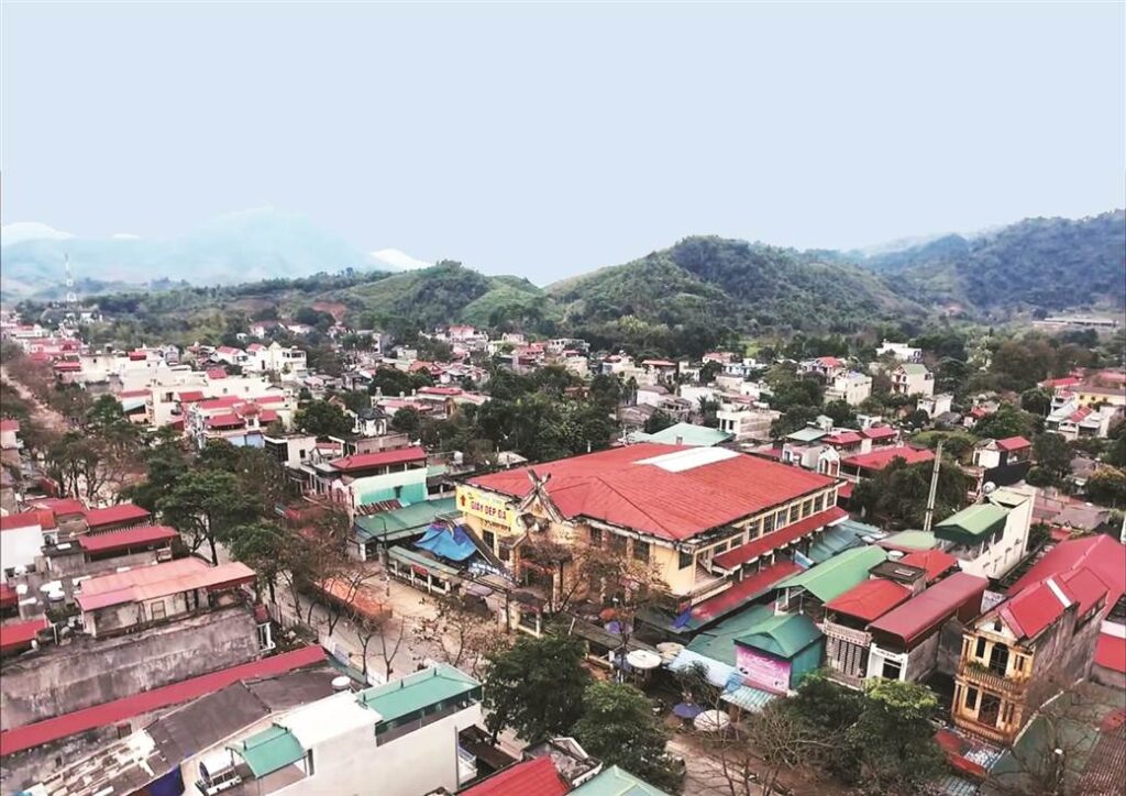
Vi Xuyen is one of the eleven administrative districts of Ha Giang province, situated in Vietnam’s northernmost region. The district covers approximately 1,430 square kilometers, making it one of the larger administrative divisions in the province. Its northern boundary forms part of Vietnam’s international border with China, giving the district strategic importance throughout history. Today, this former battleground has transformed into a peaceful area of natural beauty and cultural diversity.
The district takes its name from two Sino-Vietnamese words: “Vị” meaning “position” and “Xuyên” meaning “stream” or “river,” reflecting the region’s geographical character with its many waterways cutting through mountain valleys. Home to multiple ethnic groups including the Tay, Nung, Dao, and H’mong peoples, Vi Xuyen offers a rich tapestry of cultural traditions, architectural styles, and agricultural practices that have adapted to the highland environment over centuries. The district’s population of approximately 100,000 residents primarily engages in agriculture, with rice cultivation on terraced fields being the dominant livelihood.
Vi Xuyen serves as an important gateway to the more famous Dong Van Karst Plateau Geopark further north, yet has managed to maintain its authentic character away from mainstream tourism routes. The district town, also called Vi Xuyen (or sometimes Vi Xuyen town), functions as the administrative center where government offices, schools, and basic commercial services can be found. While less visited than other parts of Ha Giang, the district rewards travelers with genuine interactions, untouched landscapes, and a deeper understanding of Vietnam’s northern borderlands.
Vi Xuyen district, formerly in Ha Giang Province, now belongs administratively to Tuyen Quang Province following the merger effective 1 July 2025.

Ha Giang travel route map updated after the July 1, 2025 merger
2. Geography & Location
Vi Xuyen district occupies a transitional zone between the Red River Delta and the Himalayan highlands, characterized by increasingly dramatic topography as you move northward. The district’s southern portions feature rolling hills and wider valleys, while the northern reaches present steep limestone mountains, narrow valleys, and karst formations. Elevations range from approximately 200 meters above sea level in the lowest valleys to peaks exceeding 1,500 meters along the Chinese border, creating diverse microclimates and vegetation zones.
The district is traversed by several important waterways, including the Lo River (a major tributary of the Red River) which flows through its central valley, providing irrigation for agriculture and traditionally serving as a transportation route. Numerous smaller streams carve the limestone landscape, creating scenic valleys and occasional waterfalls hidden among the hills. These waterways have historically defined settlement patterns, with villages typically established near reliable water sources and on arable land. The mountainous terrain has historically made travel difficult, contributing to the preservation of distinct cultural identities among different communities.
The climate of Vi Xuyen follows the northern Vietnamese highland pattern, with four distinct seasons. Winters (December to February) can be surprisingly cold, with temperatures occasionally dropping below 10°C and fog frequently shrouding the mountains. Spring (March to May) brings warmer temperatures and occasional rain, while summers (June to August) are hot and humid with frequent heavy downpours during the monsoon season. Autumn (September to November) offers perhaps the most pleasant weather, with cooling temperatures, reduced rainfall, and clear skies that showcase the landscape’s beauty. This seasonal variety creates constantly changing scenery, from misty mountains in winter to vibrant green rice terraces in summer.

3. History and Wars
Vi Xuyen’s strategic position along historic trade routes and its proximity to China have placed it at the crossroads of numerous historical developments. Archaeological findings suggest human settlement in the area dates back several thousand years, with evidence of early agricultural communities establishing themselves along river valleys. Throughout much of its early history, the region fell within the sphere of influence of various Chinese dynasties, though geographical isolation allowed local cultures to maintain their distinct identities and practices. During Vietnam’s dynastic periods, the area served as a frontier zone, often administered through local chieftains who paid tribute to Vietnamese emperors.
The French colonial period brought increased administrative attention to the region, with the establishment of military outposts and rudimentary infrastructure. The colonial authorities recognized the area’s strategic importance as a buffer zone with China, leading to efforts to strengthen control over mountain passes and transportation routes. During the First Indochina War (1946-1954) against French forces, the mountains of Vi Xuyen provided hiding places for Vietnamese resistance fighters, establishing a tradition of strategic defense that would continue in later conflicts.
Following Vietnam’s division and the American War (1955-1975), Vi Xuyen briefly enjoyed a period of peace before becoming embroiled in the Sino-Vietnamese conflicts that erupted after 1979. The district’s border regions became the frontline in a series of battles that would continue intermittently for over a decade, leaving lasting physical and psychological imprints on the landscape and its people. Today, these historical layers remain visible throughout the district, from ancient agricultural terraces to French colonial buildings and solemn war memorials that commemorate more recent sacrifices.
3.1 Battle of Vi Xuyen / Laoshan (1984)
The most significant military engagement in Vi Xuyen’s recent history occurred in 1984, when Chinese forces launched a major offensive against Vietnamese positions along the border. Known internationally as the Battle of Laoshan and to Vietnamese as the Battle of Vi Xuyen, this conflict represented one of the largest engagements in the decade-long border war that followed China’s 1979 invasion of northern Vietnam. The battle centered on several strategic mountain positions along the border, particularly the elevated areas that provided artillery observation points overlooking key valleys and transportation routes.
Beginning in April 1984, Chinese forces conducted heavy artillery bombardments of Vietnamese defensive positions before launching infantry assaults on strategically significant high ground. The Vietnamese defenders, many of them battle-hardened veterans from the American War, responded with determined resistance. The fighting was characterized by its intensity and the difficult mountain terrain, with soldiers on both sides enduring harsh conditions in addition to enemy fire. Artillery exchanges were particularly devastating, with thousands of shells fired daily during peak periods of the battle. Some veterans recall that certain hills were so heavily shelled that their original heights were reduced by several meters.
The battle resulted in heavy casualties on both sides, with estimates suggesting several thousand soldiers killed or wounded. While Chinese forces succeeded in capturing certain high points along the border, Vietnamese troops maintained their defense of key positions, preventing a deeper incursion into national territory. Fighting would continue intermittently in the area until 1988, with sporadic artillery exchanges occurring even later. The legacy of this conflict remains visible today in the numerous military cemeteries throughout Vi Xuyen district, which contain the graves of thousands of Vietnamese soldiers who fell defending the northern frontier. These solemn sites, along with memorials and museums, now serve as important historical markers and destinations for domestic tourists paying respect to national martyrs.

4. Administrative Divisions
Vi Xuyen district is organized into 24 administrative units: one district town and 23 communes (xã). The district town, also called Vi Xuyen, serves as the administrative headquarters where district-level government offices, the central market, schools, and healthcare facilities are concentrated. This town sits approximately 20 kilometers north of Ha Giang city along National Highway 2, making it relatively accessible compared to the more remote communes. With a population of around 8,000 residents, the town offers basic services for travelers including simple hotels, restaurants, and transportation connections.
The 23 communes vary considerably in size, population, and accessibility. Southern communes like Phuong Tien, Ngoc Linh, and Phuong Do benefit from proximity to Ha Giang city and flatter terrain, supporting more intensive agriculture and better infrastructure. Central communes such as Thuong Son, Thanh Thủy, and Thanh Đức stretch along the Lo River valley, where rice cultivation dominates the landscape. The northern communes of Thanh Thuy, Lao Chai, and Xin Chai extend into increasingly mountainous territory toward the Chinese border, where communities are more isolated and transportation more challenging.
Population distribution follows geographical patterns, with denser settlements in the river valleys and more scattered, smaller villages in the mountains. Ethnic composition also varies by location, with Tay and Nung communities predominantly in lower elevations and river valleys, while H’mong and Dao villages typically occupy higher altitudes. This distribution reflects historical adaptations to different ecological niches, with each group developing agricultural systems suited to their environment. Administrative boundaries generally respect these traditional settlement patterns while organizing communities into manageable units for governance purposes, though some communes contain mixed populations of several ethnic groups coexisting in close proximity.

5. Culture, Demographics & Economy
Vi Xuyen’s cultural landscape is shaped by its diverse ethnic composition, with each group maintaining distinct traditions, languages, housing styles, and cultural practices. The Tay people, the largest minority group in the district, typically live in stilt houses in valley locations, practicing wet rice agriculture and maintaining animist belief systems alongside Buddhism. The Nung share many cultural similarities with the Tày but often maintain separate communities with subtle differences in costume, dialect, and customs. In higher elevations, H’mông communities are recognized for their colorful traditional dress, unique musical traditions, and extensive knowledge of medicinal plants.
Traditional architecture varies significantly among ethnic groups, with most adapting housing styles to local conditions. Tay and Nung stilt houses typically feature wooden structures raised above ground level to protect against flooding and provide space for livestock below. H’mong houses in higher elevations are often built directly on the ground with thick walls for insulation against colder temperatures. All groups share a tradition of community gatherings for festivals, weddings, and harvest celebrations, often centered around communal houses or sacred spaces. These events feature traditional music, dance, and cuisine that remain vibrant aspects of local culture despite modernizing influences.
The district’s economy remains predominantly agricultural, with rice cultivation forming the backbone of subsistence farming. Terraced rice fields are particularly impressive in the northern communes, where generations of farmers have transformed steep slopes into productive land. Beyond rice, corn, cassava, and various vegetables are cultivated for both subsistence and increasingly for commercial markets. Animal husbandry, particularly the raising of buffalo, pigs, and chickens, provides additional income and protein sources. Small-scale forestry activities, including the harvesting of bamboo and timber, supplement agricultural income in many communities. Recent years have seen growing interest in developing tourism infrastructure, particularly in areas with significant historical sites or natural beauty, though this sector remains in its early stages compared to other parts of Ha Giang province.
Top 4 rice fields Vietnam destinations & perfect times to go
6. Tourism, Monuments & Notable Sites
Though less developed for tourism than neighboring districts, Vi Xuyen offers authentic experiences for travelers interested in history, culture, and natural landscapes away from well-trodden paths. The district’s tourism infrastructure remains basic, with limited accommodation options outside the district town, making it ideal for day trips from Ha Giang city or as part of a larger circuit through the province. The most accessible sites lie along National Highway 2, which runs north-south through the district, though more adventurous travelers can explore remote communes via secondary roads that may require appropriate vehicles and local guidance.
The district’s position as a gateway to northern Ha Giang places it on the route to more famous destinations like the Dong Van Karst Plateau, meaning many travelers pass through without exploring its own attractions. However, this creates opportunities for more meaningful interactions with local communities less accustomed to foreign visitors. Community-based tourism initiatives have begun to emerge in several communes, offering homestay experiences that provide insights into traditional lifestyles while generating supplementary income for local families. Phieu Travel offers guided excursions that combine historical sites with village visits and scenic drives, providing context and translation that enhance understanding of this multifaceted region.
For independent travelers, the district town makes a practical base with its simple hotels and restaurants serving local cuisine. Transportation options include motorcycle rental (the most flexible option for exploring), local buses serving major routes, and taxi services for shorter journeys. When planning a visit, consider the seasonal variations in weather; the October-November period offers comfortable temperatures and clear skies ideal for photography, while the spring months of March-April showcase blossoming fruit trees and the preparation of rice terraces for planting. Regardless of timing, Vi Xuyen rewards visitors who approach with curiosity, respect, and willingness to venture beyond typical tourist experiences.
6.1 War Memorials & Cemeteries
Vi Xuyen’s most somber yet historically significant sites are its war memorials and military cemeteries, which commemorate the soldiers who died defending Vietnam’s northern border. The largest of these is the Vi Xuyen Martyrs’ Cemetery, located approximately 7 kilometers north of the district town. This extensive memorial complex contains the graves of thousands of soldiers who fell during the border conflicts with China, particularly during the intense fighting of 1984-1988. Rows of simple white headstones stretch across carefully maintained grounds, each marking an individual sacrifice. A central monument bears inscriptions honoring the collective sacrifice, while a small museum displays photographs, personal effects, and historical information about the conflict.
Several smaller cemeteries and memorial sites are scattered throughout the northern communes, often marking locations of particularly fierce battles or dedicated to units that fought in specific areas. These sites, while less frequently visited by international tourists, hold deep significance for Vietnamese visitors, particularly military veterans and families of the fallen. Official commemorations take place on several occasions throughout the year, notably on Vietnamese Martyrs’ Day (July 27) and during the Lunar New Year period, when families visit to pay respects to ancestors and fallen soldiers are remembered alongside family members.
Beyond formal memorials, the landscape itself bears witness to the conflicts, with certain hillsides and passes marked by remnants of trenches, bunkers, and occasionally unexploded ordnance (though major areas have been cleared for safety). Several observation points along Highway 2 provide views toward the border areas where the fighting was most intense, often marked with informational signs explaining the historical significance. For visitors interested in this aspect of Vi Xuyen’s history, engaging a knowledgeable local guide is recommended, as they can provide context and personal or family stories that bring deeper understanding to these powerful sites of memory and reflection.

6.2 Natural Attractions (Waterfalls, Mountains, Trekking)
Beyond its historical significance, Vi Xuyen offers natural landscapes of remarkable beauty, particularly in its less-developed northern communes. The district’s varied topography creates numerous scenic vistas, from terraced rice fields that transform with the seasons to dramatic limestone formations that emerge from morning mist. Several viewpoints along the main highway provide easily accessible panoramas, while more remote areas reward those willing to venture on secondary roads or hiking trails. During clear weather, views toward the Chinese border reveal the mountainous frontier that has shaped the region’s history and culture.
Water features prominently among Vi Xuyen’s natural attractions, with the Lo River providing a scenic corridor through the district’s central valley. Several smaller waterfalls can be found in the district’s mountainous areas, particularly during and after the rainy season when streams run full. Notable among these is Tien Waterfall in Cao Bo commune, where water cascades approximately 70 meters down a limestone cliff into a natural pool below. The less-visited Nam Dan waterfall in the northwestern part of the district offers a more secluded experience, requiring a moderate hike through forests but rewarding visitors with pristine surroundings and few, if any, other tourists.
For trekking enthusiasts, Vi Xuyen offers numerous possibilities ranging from half-day walks to multi-day adventures connecting remote villages. The varied terrain provides options for different fitness levels, though most routes involve some steep sections given the mountainous nature of the district. Several communes have begun developing community-based trekking programs where local guides lead visitors through scenic areas while sharing knowledge of local plants, traditional agriculture, and cultural practices. These experiences typically include homestay accommodations in village houses, providing authentic immersion in local life while supporting community livelihoods. Phieu Travel can arrange these trekking experiences with reliable local guides who ensure both safety and meaningful cultural exchange, making Vi Xuyen’s natural wonders accessible while respecting local communities and environments.

The Ultimate Ha Giang Loop Guide (2025): Itinerary, Map & Tips
7. Practical Information for Visitors
Reaching Vi Xuyen is relatively straightforward, as the district lies just 20 kilometers north of Ha Giang city along National Highway 2. Regular public buses connect the provincial capital with Vi Xuyen town, typically departing hourly from early morning until late afternoon. For greater flexibility, many visitors rent motorcycles in Ha Giang city, allowing independent exploration of both main roads and secondary routes. Those less comfortable with self-driving can arrange private transportation through hotels or tour operators like Phieu Travel, who offer driver services with vehicles appropriate to the sometimes challenging road conditions.
Accommodation options remain limited but adequate for the district’s current tourism level. In the district town, several small hotels and guesthouses offer basic but clean rooms typically ranging from 200,000 to 400,000 VND per night. For more authentic experiences, homestay options have emerged in several communes, particularly those along trekking routes or near natural attractions. These family homes typically offer simple sleeping arrangements (often mattresses with mosquito nets in a shared space), home-cooked meals featuring local specialties, and valuable cultural exchange. Advance booking is recommended, especially during Vietnamese holiday periods when domestic tourism increases.
Local cuisine reflects the agricultural bounty of the region and the traditions of its ethnic groups. Rice forms the staple, often accompanied by vegetables grown in family gardens or gathered from forest areas. Protein sources include pork, chicken, and occasionally beef or buffalo meat, typically prepared in stir-fries or slow-cooked stews with local herbs and spices. Fish from the Lo River and smaller streams appears frequently on menus, often grilled or in sour soups. Local specialties worth trying include thắng cố (a hearty meat stew popular among H’mông communities), smoked meats preserved over kitchen fires, and various pickled vegetables that add distinctive flavors to meals. Visitors with dietary restrictions should communicate these clearly when arranging homestays, as concept of vegetarianism may be less familiar in rural areas.
8. Getting Around Vi Xuyen District
Navigating Vi Xuyen’s varied terrain requires some planning, with transportation options depending on your destination and comfort level. The main artery, National Highway 2, is well-maintained and suitable for all vehicles, connecting the district town with Ha Giang city to the south and continuing north toward Đồng Văn. Provincial roads branching from this highway vary considerably in quality, with those serving central communes generally paved but narrower, while roads to more remote areas may include unpaved sections that become challenging during rainy periods. If venturing beyond main routes, especially in northern communes, motorcycles or 4WD vehicles are recommended.
Public transportation within the district operates primarily along Highway 2 and major provincial roads, with small buses and shared vans connecting the district town to larger communes. These services run on loose schedules, typically departing when vehicles fill rather than at fixed times, and may be infrequent to more remote areas. For travelers with limited time or specific destinations in mind, hiring a motorcycle taxi (xe ôm) for shorter trips or arranging a car with driver for the day provides more reliability and flexibility. Drivers typically charge by distance or by day, with rates negotiable but generally reasonable.
For the adventurous, exploring by motorcycle offers the greatest freedom to discover viewpoints, villages, and natural sites off the main tourist track. Basic motorcycles can be rented in both Ha Giang city and Vi Xuyen town for approximately 150,000-250,000 VND per day. When traveling this way, carry a detailed map (physical maps are more reliable than digital in areas with limited mobile coverage), dress appropriately for changing weather conditions, and ensure your rental includes helmets and basic roadside assistance. Some remote areas may require permits, particularly those very close to the Chinese border, so checking requirements in advance or traveling with a local guide can prevent complications. Whatever your chosen mode of transport, allow extra time for journeys, as road conditions, weather, and unexpected local events can affect travel times in this mountainous region.
9. Best Time to Visit Vi Xuyen District
Vi Xuyen experiences four distinct seasons, each offering different advantages and challenges for visitors. The autumn months from September to November provide perhaps the most favorable conditions, with decreasing rainfall, moderate temperatures (typically 15-25°C), and excellent visibility that showcases the landscape’s beauty. This period coincides with the rice harvest in many areas, when terraced fields turn golden and harvest activities animate rural communities. October in particular offers comfortable trekking conditions and photogenic landscapes, with clear skies and reduced humidity making outdoor exploration pleasant throughout the day.
Spring (February to April) presents another attractive window, as fruit trees blossom throughout the district and fields are prepared for planting. Temperatures gradually warm from the winter chill, though evenings remain cool enough to require light jackets. This season brings occasional rain showers that nourish the emerging greenery but rarely persist long enough to significantly disrupt travel plans. Cultural activities increase during this period, particularly around Tết (Lunar New Year), when families gather and traditional celebrations take place in villages throughout the district. While this can enhance cultural experiences, accommodation may require advance booking during the Tết holiday itself.
Summer (May to August) coincides with the monsoon season, bringing higher temperatures (sometimes exceeding 30°C in lower elevations) and frequent heavy rainfall. While this creates lush green landscapes and impressive water volumes at waterfalls, it also presents challenges for travelers. Roads to remote areas may become slippery or occasionally impassable after heavy downpours, and outdoor activities often require flexible scheduling around weather conditions. Winter (December to January) brings dry conditions but surprisingly cold temperatures, particularly at night when readings can drop below 10°C. Morning fog frequently shrouds mountain areas, creating ethereal landscapes but sometimes limiting visibility at scenic viewpoints. For those properly prepared with warm clothing, winter offers uncrowded conditions and a different perspective on the highland environment.

10. Final Thoughts on Exploring Vi Xuyen District
Vi Xuyen district offers travelers an authentic window into Vietnam’s northern borderlands, where history, culture, and natural beauty intersect away from mainstream tourist circuits. Its unique position—close enough to Ha Giang city for convenient access yet removed enough to maintain its distinctive character—makes it an ideal addition to northern Vietnam itineraries, whether as a day trip or a deeper exploration over several days. What the district lacks in famous landmarks it compensates for with genuine experiences, from interactions with ethnic minority communities practicing traditional lifeways to contemplative moments at historical sites that have shaped national memory.
The district’s development trajectory suggests that now is an opportune time to visit, as basic tourism infrastructure exists but has not yet transformed local communities or landscapes. Travelers who approach with respect, curiosity, and patience will find residents generally welcoming, if sometimes reserved initially. Learning a few basic Vietnamese phrases, showing interest in local customs, and asking permission before photographing people or their homes goes a long way toward meaningful cultural exchange. The minor inconveniences of limited English signage or occasional communication challenges are far outweighed by the rewards of experiencing a region where daily life continues largely unaffected by tourism’s homogenizing influence.
As you plan your journey through northern Vietnam, consider allocating time to explore Vi Xuyen’s multifaceted offerings beyond a simple pass-through en route to more famous destinations. Whether you’re drawn by historical interest, cultural curiosity, or the appeal of less-traveled landscapes, this frontier district rewards thoughtful exploration. The Ha Giang Loop by Phieu Travel specializes in creating experiences that balance the district’s highlights with hidden gems, connecting travelers with knowledgeable local guides who enhance understanding while ensuring respectful engagement with communities and environments. Visit Phieutravel.com to discover how this distinctive corner of Ha Giang province can become a meaningful part of your Vietnamese journey, offering perspectives and memories that extend far beyond the typical tourist experience in Vi Xuyen district, Ha Giang.
- Conquer Tay Con Linh Peak – Ha Giang’s Highest Mountain 2025
- Ha Giang Weather in September: Complete Guide for Travelers
- Top 20 Ha Giang homestays with scenic views (2025)
You Might Also Like
Ha Giang Weather in September: Complete Guide for Travelers
Exploring the magnificent Ha Giang Loop in September offers travelers a perfect balance of favorable[...]
3 Comments
Quan Ba Twin Mountains: Ha Giang’s Iconic Fairy Hills and Complete Travel Guide
The mystical Quan Ba Twin Mountains rise from the emerald valleys of Ha Giang like[...]
Vuong family mansion: the architectural marvel and cultural legacy of Ha Giang
Deep in Vietnam’s northern highlands, where mist-shrouded mountains meet terraced rice fields, stands a testament[...]
Ha Giang Loop Safety Tips: How to Ride Securely in Vietnam’s Northern Mountains
The Ha Giang Loop, with its winding mountain roads and breathtaking landscapes, offers one of[...]
The Ultimate Guide to the M-Shaped Curve on Ha Giang Loop
Vietnam’s remote northern province of Ha Giang hides a natural wonder that has captivated adventurous[...]
Most Beautiful Places to Visit in Vietnam: Essential Destinations and Insider Tips
Vietnam captivates travelers with its stunning landscapes, rich cultural heritage, and warm hospitality. From mist-shrouded[...]
3 Comments
Beyond the Beaten Path: Discovering Ha Giang Province in Northeast Vietnam
Ha Giang Province in Northeast Vietnam stands as one of the country’s last frontiers for[...]
6 Comments
Rainy season in Ha Giang: what to expect, when to go, and travel tips
Vietnam’s northern frontier reveals a different face during the rainy season, transforming Ha Giang’s limestone[...]